|
Manuscripts |
MS 154/1 |
Caithness Coastal Survey |
Caithness Coastal Survey:Interim reports & Original Manuscript |
1980 |
Item Level |
|
|
Manuscripts |
MS 154/10 |
Caithness Coastal Survey |
Annotated xeroxes of OS map |
1982 |
Item Level |
|
|
Manuscripts |
MS 154/11 |
Caithness Coastal Survey |
Miscellaneous correspondence relating to survey |
1980 |
Item Level |
|
|
Manuscripts |
MS 154/12 |
Caithness Coastal Survey |
Complete list of plans |
1980 |
Item Level |
|
|
Manuscripts |
MS 154/2 |
Caithness Coastal Survey |
Caithness Coastal Survey: Interim report 1981 |
1981 |
Item Level |
|
|
Manuscripts |
MS 154/3 |
Caithness Coastal Survey |
Caithness Coastal Survey: Interim report |
1980 |
Item Level |
|
|
Manuscripts |
MS 154/4 |
Caithness Coastal Survey |
Record Notebook Vol I |
1980 |
Item Level |
|
|
Manuscripts |
MS 154/5 |
Caithness Coastal Survey |
Record Notebook Vol II |
1981 |
Item Level |
|
|
Manuscripts |
MS 154/6 |
Caithness Coastal Survey |
Field Notebooks (4 books) |
1980 |
Item Level |
|
|
Manuscripts |
MS 154/7 |
Caithness Coastal Survey |
Field Notebooks (3 books) |
1981 |
Item Level |
|
|
Manuscripts |
MS 154/8 |
Caithness Coastal Survey |
Field Notebooks (5 books) |
1982 |
Item Level |
|
|
Manuscripts |
MS 154/9 |
Caithness Coastal Survey |
Record cards |
1980 |
Item Level |
|
|
Prints and Drawings |
CAD 229/1 |
Caithness Coastal Survey |
Plans of general survey area. |
1982 |
Item Level |
|
|
Prints and Drawings |
CAD 229/2 |
Caithness Coastal Survey |
Plans of general survey area. |
1982 |
Item Level |
|
|
Prints and Drawings |
CAD 229/5 |
Caithness Coastal Survey |
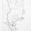
Canisbay (East) Map |
1982 |
Item Level |
|
|
Manuscripts |
MS 154/13 |
Caithness Coastal Survey |
Caithness Coastal Survey: Interim reports |
1980 |
Item Level |
|
|
Photographs and Off-line Digital Images |
CAD 229/1 P |
Caithness Coastal Survey |
General survey area plan. |
1982 |
Item Level |
|
|
Photographs and Off-line Digital Images |
CAD 229/2 P |
Caithness Coastal Survey |
General Survey Area Plans |
1982 |
Item Level |
|
|
Prints and Drawings |
CAD 229/5 P |
Caithness Coastal Survey |
Canisbay (East) Map |
1982 |
Item Level |
|
 |
On-line Digital Images |
SC 1926335 |
Caithness Coastal Survey |
General survey area plan. |
1982 |
Item Level |
|
 |
On-line Digital Images |
SC 1926338 |
Caithness Coastal Survey |
Canisbay (East) Map |
1982 |
Item Level |
|
 |
On-line Digital Images |
SC 2354907 |
Records of the Ordnance Survey, Southampton, Hampshire, England |
Greenie Geo, ND36SE 15, Ordnance Survey index card, page number 1, Recto |
c. 1958 |
Item Level |
|
|
All Other |
551 166/1/1 |
Records of the Ordnance Survey, Southampton, Hampshire, England |
Archaeological site card index ('495' cards) |
1947 |
Sub-Group Level |
|


