
Pricing Change
New pricing for orders of material from this site will come into place shortly. Charges for supply of digital images, digitisation on demand, prints and licensing will be altered.
Nybster


Mound (Period Unassigned)
Site Name Nybster
Classification Mound (Period Unassigned)
Alternative Name(s) Wic 090
Canmore ID 9309
Site Number ND36SE 11
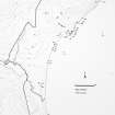
NGR ND 3665 6323
Datum OSGB36 - NGR
Permalink http://canmore.org.uk/site/9309


- Council Highland
- Parish Wick
- Former Region Highland
- Former District Caithness
- Former County Caithness
ND36SE 11 3665 6323.
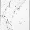
(Area ND 367 633) A low mound lies some 300 yds S of the school at Nybster, close beside the road on the W side. It was excavated by Sir Francis Tress Barry and was found to contain 'a circular building with a diameter of about 6ft, having a semi-circular recess with a radius of about 3ft opening out of it at the back. There was an entrance from the NE, about 2ft wide, between two large stones laid on edge. The whole structure is said to have shown evidence of having been affected by fire. The wall was about 2ft 6ins in thickness, and existed to a height of about 3ft. In the interior there was found a thin flat sandstone slab, measuring about 17ins in length, 7 1/2ins in breadth and 2ins in thickness, perforated at one end with a hole drilled from both sides. There was also discovered a human jaw partially consumed by fire, and two other human bones. The structure was filled up after examination.
RCAHMS 1911, visited 1910.
This structure, at ND 3665 6323 is now visible as a grass-covered mound 14.0m in diameter by 0.5m high. The 'slab' mentioned by the RCAHMS is in the Nicolson Exhibition at Nybster marked as a 'weight'.
Surveyed at 1:2500.
Visited by OS (R D) 26 October 1965.
A now grass-covered mound, about 6m in diameter, which was excavated by Tress-Barry to reveal a circular building about 1.8m in diameter, possibly a kiln.
Visited by OS (R D) 26 October 1965.
The mound is ploughed down and was planted with barley at the time of investigation. The farmer has found nothing of significance whilst cultivating the mound apart from a greater concentration of stones.
Visited by OS (N K B) 22 July 1982.
Field Visit (1910)
(Area ND 367 633) A low mound lies some 300 yds S of the school at Nybster, close beside the road on the W side. It was excavated by Sir Francis Tress Barry and was found to contain 'a circular building with a diameter of about 6ft, having a semi-circular recess with a radius of about 3ft opening out of it at the back. There was an entrance from the NE, about 2ft wide, between two large stones laid on edge. The whole structure is said to have shown evidence of having been affected by fire. The wall was about 2ft 6ins in thickness, and existed to a height of about 3ft. In the interior there was found a thin flat sandstone slab, measuring about 17ins in length, 7 1/2ins in breadth and 2ins in thickness, perforated at one end with a hole drilled from both sides. There was also discovered a human jaw partially consumed by fire, and two other human bones. The structure was filled up after examination.
RCAHMS 1911, visited 1910.
Field Visit (26 October 1965)
This structure, at ND 3665 6323 is now visible as a grass-covered mound 14.0m in diameter by 0.5m high. The 'slab' mentioned by the RCAHMS is in the Nicolson Exhibition at Nybster marked as a 'weight'.
Surveyed at 1:2500.
Visited by OS (R D) 26 October 1965.
Field Visit (26 October 1965)
A now grass-covered mound, about 6m in diameter, which was excavated by Tress-Barry to reveal a circular building about 1.8m in diameter, possibly a kiln.
Visited by OS (R D) 26 October 1965.
Project (1980 - 1982)
Field Visit (22 July 1982)
The mound is ploughed down and was planted with barley at the time of investigation. The farmer has found nothing of significance whilst cultivating the mound apart from a greater concentration of stones.
Visited by OS (N K B) 22 July 1982.

