
Ness


Broch (Iron Age)(Possible)
Site Name Ness
Classification Broch (Iron Age)(Possible)
Alternative Name(s) Can 074
Canmore ID 9260
Site Number ND36NE 1
NGR ND 3814 6665
Datum OSGB36 - NGR
Permalink http://canmore.org.uk/site/9260


- Council Highland
- Parish Canisbay
- Former Region Highland
- Former District Caithness
- Former County Caithness
ND36NE 1 3814 6665.
(ND3814 6665) Broch (NR)
OS 1:10,000 map, (1975)
Ness Broch (Anderson 1901), the remains of a 2nd to 3rd century (Young 1964) broch situated at the landward end of a promontory which is cut off at the neck by a strong wall. Accompanying settlement lies both inside and outside the wall.
The broch, which was excavated by Sir Francis Tress Barry between 1890 and 1901, and re-excavated by MacKie in 1972, has had a diameter of 22ft within a wall about 15ft thick, with two unchecked entrances, one, simple, facing SW or landward and the other, with a guard chamber on the S side, facing E or seaward. The broch wall has been so damaged that its faces are virtually untraceable, only secondary walling giving an approximate indication of its line. Bronze ingots, an ingot mould, and links of a bronze chain were found in a mural chamber to the N of the E entrance.
The wall across the neck of the promontory is 6ft high and has a depression in front of it in which there is a well, 9ft 6ins deep, but now filled in, roofed with slabs and having twelve steps leading down to it. The RCAHMS plan suggests that there is a continuation of the wall on the opposite side of the ravine to the N of the peninsula, indicating that it has been cut by natural erosion.
Likewise, the settlement lies on both sides of the ravine. One of the chambers on the N side has a tank-like construction of slabs set into the floor, and an annexe 9ft by 6ft, the walls of which are 4ft high, with a base of slabs set on edge. There are also remains of less well preserved outbuildings on the peninsula E of the broch. The local name for the site, 'byke Yards' (Ordnance Survey Name Book [ONB] 1873) may be an indication of the original shape of the outbuildings, since a 'dyke' was a beehive-shaped granary (Jamieson 1818). Finds from Sir Francis Tress Barry's excavation were donated to the National Museum of Antiquities of Scotland (NMAS) in 1908.
J Anderson 1901; Proc Soc Antiq Scot 1908; RCAHMS 1911, visited 1910; A Young 1964; Name Book 1873; J Jamieson 1818; E W MacKie 1972.
The Ness Broch, generally as described and planned, is situated on a sheer promontory, its outer face having been destroyed by erosion on the N and SE and being visible only at the E entrance. Erosion has also reduced the outer wall across the promontory, and an outbuilding on the landward side of the broch. Only a slight depression marks the position of the well and there is no trace of the 'tank-like structure' in the outer enclosure.
At ND 3810 6665, to the W of the broch, is a grass-covered stony mound, 0.8m high and 8m in diameter which may be an original feature or spoil from the excavation. A modern monument has been built seaward of the broch.
Resurveyed at 1:2500.
Visited by OS (N K B) 16 September 1965.
Broch of Ness has been identified with 'Lambaborg', mentioned at about 1143 in the Orkneyinga Saga, where the adventurer Sweyn Asleifsson stood siege (but see also ND36NE 7). A broad ditch cuts the promontory immediately outside the massively stone-revetted rampart.
R G Lamb 1980.
No change to the previous field report.
Visited by OS (J B) 21 July 1982.
Project (1980 - 1982)
Publication Account (2007)
ND36 8 NESS ND/3814 6665 (visited in 1963, 1971 and 1972)
An unusually small probable solid-based broch in Canisbay, Caithness, excavated by Sir F Tress Barry in 1898; the results were briefly described by Anderson with no details of any deposits found [2]. A limited amount of clearance of the interior wallface was undertaken by the author in 1972, mainly for the purpose of making an exact plan.
Description
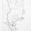
The broch is situated at the landward end, or neck, of a cliff promontory which projects eastwards about 24m into the sea and is apparently defended by a massive cross wall, 19.5m (64ft) long and 1.83m (6ft) high, running across the neck. The plan suggests that erosion since the Iron Age has caused a gully to breach this wall at its north end and that it once ran about 3.66m (12ft) further north before curving round to the west, or forwards. Further erosion of the cliff immediately north-east of the broch had by 1910 already caused its outer face to fall into the sea on the south-east side. There are traces of stone buildings close to the broch on its seaward (eastern) side and also immediately west of the promontory wall.
Tress Barry's plan, drawn by Nicholson, shows two entrances, one facing south-west towards the land, and also towards the single passage through the outer wall; the other faces east towards the seaward end of the promontory. The original doorway seems certain to have been the latter; it was common practice for the entrances of brochs built on narrow strips of ground to be built facing away from the easiest approach. The south-western doorway seems to lack a door-frame and is doubtless a later insertion, comparable to those found in Keiss South and Keiss West.
The length of the primary entrance – and thus the thickness of the wall here – was 4.65m (15ft 3in); the width at the outer end is 1.12m (3ft 8in) and at the inner 1.32m (4ft 4in). An elongated guard cell was on the left side at about 1.0m (6ft 4in) from the exterior and, though no signs were recorded of checks in the passage walls, a stone sill in the presumably paved floor immediately in front of the guard cell probably marked the position of the door-frame. Any thin stone slabs forming the checks could have been removed in antiquity and the slots for them could easily have been overlooked, or at least not noted, by an excavator like Tress Barry.
The central court is exceptionally small and is recorded as circular in Tress Barry's plan, having a diameter of 6.71m (22ft) [4]. However a careful survey of the remaining face in 1971 and 1972 (in the latter year after some clearance of the inner face [6]) showed that it was far from that; some kind of geometrically constructed egg-shape may be a possibility (below).
At 5 o'clock from the main (east) doorway was visible the curved end of a long intra-mural cell or gallery running anti-clockwise and which was traced for about 4.58m (15ft) but the other end of which was not located. The second entrance on the south-west may have originally been the doorway to the intra-mural stair but no sign of any steps was recorded. The plan shows what seems to be a drain running down this passage, but this is not mentioned in any of the published accounts; it closely resembles the drain along the presumably secondary doorway in Keiss South.
It is clearer at Ness than in the cases of the Keiss brochs why a second door would have been needed if the broch ceased to be primarily a defended tower house. Here one originally had to go all the way round the tower to the seaward side to get in (as at Nybster), and the landward-facing doorway was therefore much more convenient. The plan shows various slab-built constructions in the court which ought also to be secondary, but reliable evidence is inevitably lacking.
The outer wall crossing the neck of the promontory is slightly convex as seen from the landward approach with a gateway in it about one third of the way across from the south side. It stood about 1.8m (6ft) high when first exposed, and a depression in front of it is doubtless a filled-in ditch. Whether the wall and ditch originally formed a promontory fort antedating the broch cannot be discovered without new, stratigraphical excavations but it is a distinct possibility. A well was found in front of this wall and immediately to the right of the gateway, evidently in the outer ditch; it was 2.90m (9ft 6in) deep, roofed with stone flags when found and had 12 steps leading down into it.
The curved walls of several chambers were found in front of the promontory wall and the plan suggests that they, like the wall itself, are continuous, in some way not easy to understand, with structures beyond the ravine to the north of the landward end of the promontory [7].
Discussion
It is not possible to infer much about the original form of this site, or about its history, from the meagre information available. The broch seems likely to have been a tower-like structure originally but the only evidence for this is indirect – the assumption that the eastern doorway was the original one and that the other door was made when the site became less defence-orientated, presumably when the upper parts of the tower were pulled down. The simplest hypothesis is that the promontory wall was an outer defence for the broch but one cannot be sure that it was not there earlier. Why the well was placed outside this wall is a mystery; a well suggests precautions against a siege but this one may belong to the post-broch era. There are no clear traces of a late Iron Age occupation in the finds.
Finds [3]
Metal objects included 1 broken bronze ring-headed pin, 2 bronze rings (now welded together side by side by corrosion) 16mm in diameter, 1 small spiral bronze bead, 2 tiny bronze chain links (one spiral) linked together, 1 bronze bar 223mm long by 9mm wide (found in the guard cell [4]) and a fragment of sheet bronze 70mm long.
Bone implements included 1 handle of an iron tool, 1 broken needle 9cm long with the eye broken, 3 pins (1 with a grooved head), 1 "chess pawn" or gaming piece and 2 polished implements.
Stone objects: Anderson also mentions [2] 3 querns (evidently rotary judging from the examples) and several vessels, both circular and oval. There were also 2 small circular polished pebbles [3].
Fired clay: in the guard chamber were found several moulds for casting bronze ingots and the chain links mentioned above. There was also a small clay crucible. A small sherd of neck-band Everted Rim ware was recovered in 1972 (In the Hunterian Museum, University of Glasgow).
Dimensions: External diameter c. 15.5m (52ft), internal c. 6.6m (22ft) so the wall proportion is about 58.5%, remarkably high. A survey by the author in 1971-72 showed that the central court was not exactly circular; on the assumption that the exact circularity of most of the other brochs measured in this way means that the central court was carefully planned, a geometrical egg-shape was tentatively fitted on to it . If this is correct the diameter along the 'base ' of the egg would be 6.63m and that at right angles to this 6.65 m; it would thus be easy to assume the broch to be circular if no complete plan had been made. It is interesting that an egg-shape is detectable in Swanson's plan [7]. The egg-shape's dimensions are as follows. The inner wallface along the arc from just east of north to just west of south fits closely to half an ellipse with a long axis of 6.632m and a short one of 4.974 m; these could be equivalent to 8 and 6 megalithic yards (of 0.829m) respectively. The other half of the wallface, though more ruinous, fits well to an egg-shape as shown in the plan. This is drawn with arcs the centre points of which are defined by an equilateral triangle with sides of 1.66m or 2 MY. It is not possible to decide from a single site whether this close fit has come about by chance or by design, but one can at least infer that some kind of length unit was probably involved in setting out the site.
Sources: 1. NMRS site no. ND 36 NE 1: 2. Anderson 1901, 143: 3. Proc Soc Antiq Scot 35 (1907-08) 15-16 (finds): 4. RCAHMS 1911b, 13-14, no. 33 and fig. 5: 5. Young 1962, 184: 6. E W MacKie in Discovery and Excavation Scotland 1972, 17: 7. Swanson (ms) 1985, 562-67 and plan: 8. Lamb 1980, 20, 74, 96: 9. Heald and Jackson 2001, 129-47.
E W MacKie 2007
Note (16 February 2015 - 31 May 2016)
The remains of the broch on a precipitous promontory NW of Ness Head stand behind what has probably been a stout wall with an external ditch, which bar access to the promontory across its neck on the SW. The wall, which has been drawn across the neck in a shallow arc, stood some 1.8m high when it was exposed in excavation by Sir Francis Tress Barry (Anderson 1901, 143) and has an entrance towards its SE end. Little trace of the probable ditch can be seen, partly because it is overlain to the NW of the entrance by later structures which extend NW beyond the eroded cleft of the geo running in from the sea on this side. Immediately outside the wall on the SE of the entrance Barry uncovered steps leading down into a slab-covered well 2.9m deep. The broch itself has been heavily eroded, but measures about 6.6m in diameter within a wall up to 4.6m in thickness, with possibly two entrances, that on the E with a guard chamber, and also another chamber in the wall on the NE. There are traces of buildings between the broch and the outer wall across the promontory on the WSW, and also on the seaward side on the ENE. The promontory has evidently been heavily eroded, and the interior behind the outer wall may originally have been considerably larger; it currently measures about 68m from ENE to WSW by up to 14m transversely (0.08ha), and there are traces of a low bank extending around its lip on the seaward end beyond the broch. The finds from the excavations reported by Anderson are: three quernstones, several stone vessels, a sandstone ingot mould, two bronze ingots, a bronze pin and links from a bronze chain (see also Proc Soc Antiq Scot 43 (1908-9), 15-16).
Information from An Atlas of Hillforts of Great Britain and Ireland – 31 May 2016. Atlas of Hillforts SC2818

