Exnaboe
Burnt Mound(S) (Prehistoric)
Site Name Exnaboe
Classification Burnt Mound(S) (Prehistoric)
Alternative Name(s) Houlland; Brough Head
Canmore ID 919
Site Number HU41SW 5
NGR HU 4047 1186
Datum OSGB36 - NGR
Permalink http://canmore.org.uk/site/919
- Council Shetland Islands
- Parish Dunrossness
- Former Region Shetland Islands Area
- Former District Shetland
- Former County Shetland
HU41SW 5 404 118
HU 405 125 (Calder 1965) Two circular mounds, partly composed of burnt materials, lie in a dip between two ridges, about 1/4 mile NNE of the broch at Brough Head (HU41SW 4), and about 1/2 mile east of North Exnaboe, on the south margin of what is in winter a small loch. (RCAHMS 1946, fig.524).
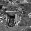
The larger measures 40ft in diameter by 5ft in greatest height. It has been opened, not, however, sufficiently to reveal the complete plan of the interior. On the S side the stones exposed are arranged in such a fashion as to suggest an entrance passage, (See photo in RCAHMS 1946, fig.521) which has originally been from 12 to 15ft long, about 2ft wide and 2ft.deep. This has been covered with large flat slabs, someof which are still in position, and one of its side stones on the E, has been trimmed along the edge as if to provide a level bed for lintel stones. The upper portion of the structure on the east side seems to have had an outer walling of large stones, within which, set in a circle of smaller diameter, upright stones show above the turf. These appear to be the terminal stones of radiating partitions, indicating a division into compartments.
The smaller mound, which is 25' distant from the larger, measures approximately 29ft by 25ft, but rises only from 18 ins to 2ft above the general level of the ground. Near its highest point there is exposed a long cist-like construction, which appears to be intrusive. It is formed of slabs about 1' in depth, set roughly end to end, and measures 5' by 1'4". The material within shows no trace of having been exposed to fire. (RCAHMS 1946).
RCAHMS 1946; C S T Calder 1965
At HU 4043 1186 are two burnt mounds as described by the RCAHMS. The larger, east mound is hollowed, revealing the scant remains of an enigmatic structure, probably a Neolithic/Bronze Age house, with upright slabs giving an internal diameter of c.3.0m. It cannot be decided whether the burnt mound overlays an earlier structure, or whether the mound has been hollowed in antiquity to accomodate a later structure. Only two stones remain of the "cist-like construction" in the smaller W mound.
Surveyed at 1/2500.
Visited by OS (NKB) 26 May 1968.
Field Visit (7 July 1933)
Mounds of Burnt Stones. Near North Exnaboe; In a dip between two ridges, about ¾ mile NNE of the broch at Eastshore of Virkie (HU41SW 4), and about ½ mile east of North Exnaboe, on the south margin of what is in winter a small loch are two circular mounds (Fig. 524), partly composed of burnt materials.
The larger measures 40ft in diameter by 5ft in greatest height. It has been opened, not, however, sufficiently to reveal the complete plan of the interior. On the S side the stones exposed are arranged in such a fashion as to suggest an entrance passage (Fig. 521) which has originally been from 12 to 15ft long, about 2ft wide and 2ft deep. This has been covered with large flat slabs, some of which are still in position, and one of its side stones on the E, has been trimmed along the edge as if to provide a level bed for lintel stones. The upper portion of the structure on the E side seems to have had an outer walling of large stones, within which, set in a circle of smaller diameter, upright stones show above the turf. These appear to be the terminal stones of radiating partitions, indicating a division into compartments.
The smaller mound, which is 25' distant from the larger, measures approximately 29ft by 25ft, but rises only from 18 ins to 2ft above the general level of the ground. Near its highest point there is exposed a long cist-like construction, which appears to be intrusive. It is formed of slabs about 1' in depth, set roughly end to end, and measures 5' by 1'4". The material within shows no trace of having been exposed to fire.
RCAHMS 1946, visited 7 July 1933.
Not noted on OS 6-inch 2nd edition.
Field Visit (26 May 1968)
At HU 4043 1186 are two burnt mounds as described by the RCAHMS. The larger, east mound is hollowed, revealing the scant remains of an enigmatic structure, probably a Neolithic/Bronze Age house, with upright slabs giving an internal diameter of c.3.0m. It cannot be decided whether the burnt mound overlays an earlier structure, or whether the mound has been hollowed in antiquity to accomodate a later structure. Only two stones remain of the "cist-like construction" in the smaller W mound.
Surveyed at 1/2500.
Visited by OS (NKB) 26 May 1968.


