
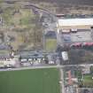
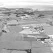
Drem Airfield


Military Airfield (Second World War), Military Airfield (First World War)
Site Name Drem Airfield
Classification Military Airfield (Second World War), Military Airfield (First World War)
Alternative Name(s) West Fenton Aerodrome; Gullane Aerodrome; Hms Nighthawk
Canmore ID 91753
Site Number NT58SW 68
NGR NT 5059 8115
NGR Description Centred NT 5059 8115
Datum OSGB36 - NGR
Permalink http://canmore.org.uk/site/91753


- Council East Lothian
- Parish Dirleton
- Former Region Lothian
- Former District East Lothian
- Former County East Lothian
Drem was known during the First World War as West Fenton and also as Gullane. It was also used during the Second World War.
The site was first used in 1915 by Royal Naval Air Service aeroplanes from East Fortune, and then from 1916 as a landing ground by No. 77 Home Defence Squadron.
Training Depots were established from 1917, when it was decided to concentrate flying training at a limited number of sites, and No.2 Training Depot was transferred to Gullane in April 1918. In August 1918 Gullane was recorded in a survey of RAF stations as ‘No. 2 Training Depot, NW Area, No 20 Group, 30th Wing’ whose function was ‘(a) A Training Depot Station (Three Unit) for Single Seater Fighter training. (b) A 6th Brigade Landing Ground 1st Class’. The latter refers to its continuing role as a landing ground for Home Defence aeroplanes.
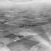
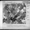
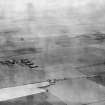
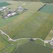
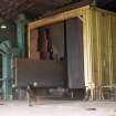
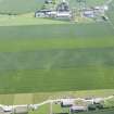
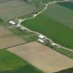
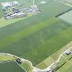
The aerodrome occupied an area of about 75 hectares, measuring 1000m by 820m, with the aerodrome buildings (of which there were over 40) on the north-east side. As was standard for training depots, there were six aeroplane hangars and an Aeroplane Repair Shed, as well as huts for teaching, workshops and accommodation for the officers who commanded the depot, their officer and Non-Commissioned Officer pupils, and the male and female service personnel who worked there. At the time of the report, in August 1918, the aerodrome buildings were still under construction, and Gullane was not included on the list of permanent air stations. In August 1918 the station’s establishment was 180 pupils, and a permanent staff of 659, of whom 216 were women. The aerodrome was designed to house 36 SE5 and 36 Avro aircraft, but it is unlikely that these numbers were achieved (The National Archives file AIR 1/452/15/312/26 vol. 1).
The Training Depot closed in November 1919 and many structures were re-used as agricultural buildings. The aerodrome was re-established on much the same site, but with mainly new buildings, in 1938. However, four First World War buildings may survive, the officers mess (see NT58SW 68.02) and three buildings of unknown purpose at NT 5069 8131.
Information from HS/RCAHMS World War One audit Project (GJB) 31 May 2013
NT58SW 68.00 Centred 5059 8115
For part of airfield which falls on map sheet se NT48SE 83.00 and see also pillbox NT58SW 67
NT58SW 68.01 centred NT 50577 80982 Aircraft Hangars; Buildings
NT58SW 68.02 centred NT 50929 81331 Building
NT58SW 68.03 centred NT 5133 8179 Cinema; Buildings
NT58SW 68.04 NT 50577 80982 Pillbox
NT58SW 68.05 NT 5095 8164 Pillbox
NT58SW 68.06 NT 5101 8132 Pillbox
NT58SW 68.07 centred NT 5107 8146 Barracks
NT58SW 68.08 centred NT 51053 80634 Sewage Works
NT58SW 68.09 centred NT 5080 8147 Buildings; Huts
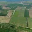
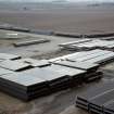
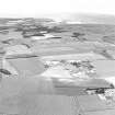
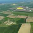
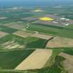
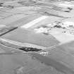
This World War One and Two airfield is situated around two miles S of Dirleton village and some of the site is now used by Fenton Barns for industrial farming.
The airfield has many buildings still extant, but no hard runways and has several good examples of dispersal bays. Various areas of the airfield have been identified at the following grid references:
Bomb Stores NT 493 809, NT 494 810, NT 494 809
Battle Headquarters NT 496 808
Dispersal Bays NT 498 803, NT 500 802
Sewage Farm NT 510 807
Pillbox NT 518 817
Shelter NT 503 804
Building NT 512 831
J A Guy 1997; NMRS MS 810/5, 178-183, 184, 185
Project (March 2013 - September 2013)
A project to characterise the quantity and quality of the Scottish resource of known surviving remains of the First World War. Carried out in partnership between Historic Scotland and RCAHMS.
Note (29 October 2021)
The Pillbox Study Group reported 29 Stanton type air raid shelters, depicted on the OS 1:2500 map (1965) across the airfield site, all of which have been demolished and removed.
The shelters were reported at these locations, NT51048139
NT 5107 8141, NT 5110 8142, NT 5114 8144, NT 5098 8147, NT 5094 8137, NT 5089 8139, NT 5096 8164, NT 5091 8153, NT 5093 8156, NT 5094 8160, NT 5093 8162, NT 5086 8138, NT 5081 8157, NT 5069 8153, NT 5068 8147, NT 5073 8146, NT 5078 8148, NT 5076 8134, NT 5077 8131, NT 5079 8121, NT 5074 8121, NT 5075 8117, NT 5064 8125, NT 5049 8126, NT 5051 8121, NT 5053 8117, NT 5050 8143 and NT 5049 8144.
Information from Pillbox Study Group to HES 29 October 2021

