
Castle Girnigoe


Castle (15th Century)
Site Name Castle Girnigoe
Classification Castle (15th Century)
Alternative Name(s) Wic 142a; Girnigow Castle; Castle Sinclair; Girnigoe-sinclair
Canmore ID 9144
Site Number ND35SE 15
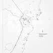
NGR ND 3783 5493
NGR Description ND 3783 5493 - ND 3779 5490
Datum OSGB36 - NGR
Permalink http://canmore.org.uk/site/9144


- Council Highland
- Parish Wick
- Former Region Highland
- Former District Caithness
- Former County Caithness
ND35SE 15 3783 5493.
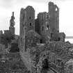
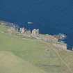
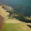
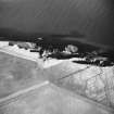
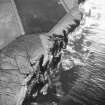
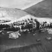
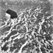
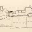
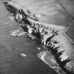
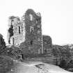
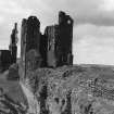
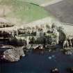
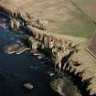
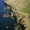
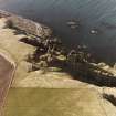
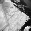
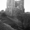
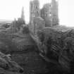
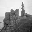
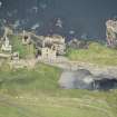
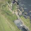
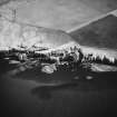
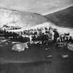
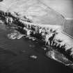
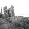
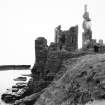
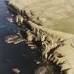
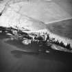
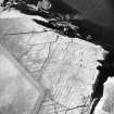
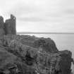
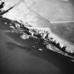
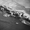
Castle Girnigoe, the earlier and better preserved of two castles (see also ND35SE 48) occupying a narrow, rocky peninsula, 400ft long and 40ft to 60ft high, which has been crossed at its neck by a partly rock-cut trench about 10ft wide and 14ft deep. About a third of the way along the peninsula is another rock-cut trench, 14ft in width and depth. Castle Girnigoe stands on the inner side, its outer ward comprising the area between the two trenches. This was defended by a gatehouse with a draw-bridge across the outer trench and a curtain wall to the south. The northern side was naturally defended by the cliffs.
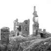
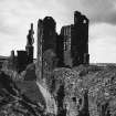
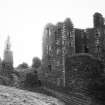
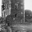
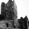
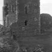
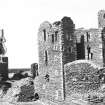
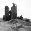
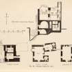
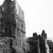
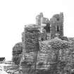
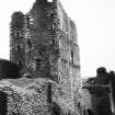
The castle, late 15th century in date, belonged to the Sinclair Earls of Caithness and was originally L-plan, the main block running N-S and rising to a height of five storeys, with the stair tower forming the second element. To this an E-W wing was added on the N, forming an E-plan. Lesser buildings occupied the area E of the main structure. The castle was defended against assault from the sea by a strong wall built across the geo to the S.
D MacGibbon and T Ross 1887-92; RCAHMS 1911; N Tranter 1962-70.
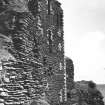
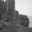
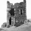
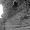
The keep of Castle Girnigoe still stands 14 to 17m high, the walls being 1.2 to 1.7m thick. The range of buildings to the NE is now a turfed-over foundation, 1.5m in maximum height. The outer ditch appears to have been a natural gully utilised as a defence.
Visited by OS 21 April 1963.
ND35SE 15 ND 378 549
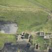
Excavation ND 378 549 A conservation plan and metric survey were completed in November 2003, and an archaeological evaluation of the outer bailey and W barbican was undertaken during 2003 and 2004. Three phases of investigation were carried out during 2005. Work focused on the W gatehouse, W range and courtyard of the outer bailey, and involved the excavation and recording of substantial rubble layers, to the level of occupation deposits.
Evidence was encountered for the structural layout of this part of the castle and significant architectural details were discovered.
The passage through the W gatehouse was excavated, involving the removal of layers of sterile rubble to a variable occupation deposit. A low wall was exposed, running along the SE edge of the passage, potentially associated with a drawbridge mechanism. A small recess in the wall adjacent to the portcullis slot is tentatively suggested to have housed a bell.
Further layers of rubble were excavated to reveal the layout of the building immediately N of the W gatehouse, previously identified as the porter's lodge. The investigations demonstrated that the porter's lodge was confined to a small room (c 5 x 2m) immediately adjacent to the gatehouse, accessed via a passage; a hearth, window and gun port were revealed. The rest of the building was dominated by one large room, accessed from the courtyard. Two large windows, one flanked by stone seats, were encountered, looking out to the courtyard and moat respectively. Sockets suggested the presence of timber panelling, and the exposed occupation deposits were seen to contain pottery and metalwork. Outside this building, in the courtyard, the window had been oversailed by a staircase, which would have led to an upper storey. Architectural stone recovered from the rubble deposits represents a collapsed oriel window.
A featureless mound to the N of this building proved to be a small irregular building, which appears to have been a later addition to the range. A small salt cupboard and remains of a window overlooking the moat were revealed.
Work undertaken in the N range added to previous phases of investigation, elucidating access to and between the three ground floor rooms. A large piece of articulated masonry was exposed within the courtyard, which appears to have formed part of the upper storey of these buildings; heat discolouration suggests the location of a hearth. Against the N and W ranges, sets of stairs were identified, leading to a first storey landing, beneath which a cupboard was identified. The discovery of timber post-holes associated with these stairs indicates the possibility of a timber gallery, running around the N and W ranges of the courtyard.
Report to be lodged with NMRS.
Sponsor: Clan Sinclair Trust.
N Toop and J Garner-Lahire 2005
ND 378 549 The 2006 season (March - August) at Castle Sinclair Girnigoe completed the archaeological excavation of the W Range and courtyard, carried out in two phases between March and August. A programme of public archaeology involved further excavation in the area of the W Barbican. Work continued in the W Range, and saw the complete excavation of rubble deposits from the room previously identified as the Porter's Lodge (DES 2005). The Outer Bailey courtyard was fully excavated, and the natural bedrock surface exposed. The slate bedrock naturally breaks down into gravel after continued exposure, which is likely to have provided the original ground surface. Work in the Courtyard provided new information on structural arrangements around the N and W Ranges. Evidence for pad stones provided further indication of the presence of timber posts, which would have supported a first floor gallery, accessed via a stone staircase which has now been fully exposed in the northern corner of the courtyard.
The excavation of a larger area over the W Barbican by volunteers exposed a sequence of stone-built features. A dry stone boundary wall of post-medieval date was encountered, running around the external edge of the dry moat. This overlay a stone slab pathway, which sloped into the dry moat itself; this feature has also been assigned a post-medieval date, and may have been installed by fishermen to provide access to the shore. This path had cut into a stone wall, running roughly N-S, which has been interpreted as structural evidence relating to the W Barbican. Associated occupation deposits abutting the wall were defined but not excavated.
Excavations at Castle Sinclair Girnigoe have produced a large quantity of architectural stone, primarily red sandstone detail from oriel windows, which has now been recorded.
Post-excavation work is ongoing, and a report is to be lodged with the NMRS.
Sponsor: Clan Sinclair Trust
Archaeology Specialists Ltd, 2006.
Publication Account (1995)
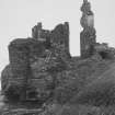
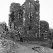
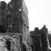
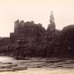
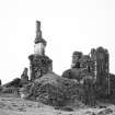
This imposing ruined castle, once the seat of the Sinciair Earls of Caithness, is set on a precipitous promontory, one side facing out to sea, the other looking over a narrow sea inlet (a 'geo' or 'goe'), and it is defended by two rock-cut ditches with an outer ward between them. Within the inner ditch stands the tall tower built in the late 15th century by William, Earl of Caithness, and behind it are lower buildings occupying all the available space. In 1607 a whole new structure was built in the outer ward, a fortification of some architectural pretension judging by the finely carved corbels which once supported angle turrets and windows. Sometimes known as Castle Sinciair, this building was an addition to the earlier castle, not a replacement. It is possible that it is built over, or incorporates, an earlier gatehouse. It is now very ruinous save for one fragment standing threestoreys high. The castle was besieged and captured in 1690 in the course of an inheritance dispute and never occupied again.
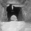
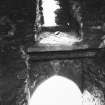
Both ditches must have been crossed by some sort of removeable wooden bridge. A vaulted passage with portcullis slot leads through the buildings in the outer court to the second ditch; this slopes down to the sea at a dangerous angle and is best approached, not from the outer court, but through the small postern gate in the south wall. The original access to the tower was by a wooden bridge to a door on the ground floor, but present entry is by a breach in the wall of a vaulted basement store or dungeon, from which a straight flight of stairs leads up.
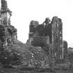
The main tower is an irregular L-plan block with an extra stair tower. It is built of thin grey Caithness flagstone with imported red sandstone dressings for the window frames and the corners. On the ground floor is a dog-leg entrance passage with two guard rooms beside it, one with a small fireplace and a stone seat. There is a kitchen in the wing behind with wall cupboards and a large fireplace, with a seat in it, filling one wall. Below the central guard chamber is another basement, perhaps once the well room, reached by a stair in the wall. All these rooms are vaulted. Food from the kitchen had to be carried across the open court to reach the stairs to the great hall. This was on the first floor, and had a fine oriel window looking west and a private room in the wing behind. In the floor of this room was a trapdoor to a hidden room above the kitchen, with a window looking out to sea. Above were bedrooms and then attics, their wooden floors and the roof long vanished.
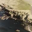
Considerable attention was given to defence, and the wall above the sea inlet had a regular row of gun-loops. Projecting from the seaward face of the castle are a line of stone corbels that held a covered wooden balcony from which defenders could rain down missiles on anyone below (or haul up the furniture: lords often carried their furniture from castle to castle, and it might not go up spiral stairs). Traces of a similar balcony exist higher up on the south face above the geo. Beyond the tower a passage leads down the narrow promontory between ruined buildings, in two of which one comes suddenly on steep stairs or shafts giving access to the sea, one halfway along and one at the far end.
The castle and the cliffs are dangerous and unsuitable for children.
Information from ‘Exploring Scotland’s Heritage: The Highlands’, (1995).
Excavation (March 2006 - August 2006)
ND 378 549 The 2006 season (March - August) at Castle Sinclair Girnigoe completed the archaeological excavation of the W Range and courtyard, carried out in two phases between March and August. A programme of public archaeology involved further excavation in the area of the W Barbican. Work continued in the W Range, and saw the complete excavation of rubble deposits from the room previously identified as the Porter's Lodge (DES 2005). The Outer Bailey courtyard was fully excavated, and the natural bedrock surface exposed. The slate bedrock naturally breaks down into gravel after continued exposure, which is likely to have provided the original ground surface. Work in the Courtyard provided new information on structural arrangements around the N and W Ranges. Evidence for pad stones provided further indication of the presence of timber posts, which would have supported a first floor gallery, accessed via a stone staircase which has now been fully exposed in the northern corner of the courtyard.
The excavation of a larger area over the W Barbican by volunteers exposed a sequence of stone-built features. A dry stone boundary wall of post-medieval date was encountered, running around the external edge of the dry moat. This overlay a stone slab pathway, which sloped into the dry moat itself; this feature has also been assigned a post-medieval date, and may have been installed by fishermen to provide access to the shore. This path had cut into a stone wall, running roughly N-S, which has been interpreted as structural evidence relating to the W Barbican. Associated occupation deposits abutting the wall were defined but not excavated.
Excavations at Castle Sinclair Girnigoe have produced a large quantity of architectural stone, primarily red sandstone detail from oriel windows, which has now been recorded.
Post-excavation work is ongoing, and a report is to be lodged with the NMRS.
Sponsor: Clan Sinclair Trust.
Archaeology Specialists Ltd 2006
Excavation (March 2007 - September 2007)
ND 3779 5490 Excavation of the North Range of the Outer Bailey courtyard was completed in March 2007. Previously identified as a West Tower and Central Range, the structure was found to comprise a single, two-storey building with three rooms at ground level. These were served by a series of garderobes, which issued directly into the sea to the N, and fireplaces. The ground floor of the North Range is now thought to represent a
service area. A staircase was identified in the northern corner of the courtyard, which would have provided access to the first floor of the North Range.
During August and September of 2007, an archaeological excavation and watching brief were carried out before and during, the construction of a new path and bridge to provide pedestrian access into the castle. The work encountered a number of stonebuilt structures associated with the West Barbican and West
Gatehouse of the castle. In the area of the West Barbican, a paved surface (F11) and overlying wall (F7), initially identified during evaluation, were further exposed, revealing the eroded, NE extent of these features where they had collapsed into the dry moat. Although this surface is known to be later than the original West Barbican building, it could relate to the latest phase of use of the castle, representing part of a formal path leading from
the West Barbican area, down into the dry moat to the South Barbican area.
At the eastern end of the new access path, a substantial area of cobbled surface (F120) was encountered, forming part of a metalled road aligned NEE/SWW. This might have been the original access road to the castle, although no secure dating evidence was recovered. A further slabbed surface (F121) was also encountered, running roughly parallel to the slope of the moat. This feature would appear to represent the continuation of F11, indicating that the slab path also continued to the SE, possibly joining the metalled road represented by F120.
Next to the West Gatehouse, a small length of wall was encountered, representing the lower courses of the SE wall of the gatehouse passage, which would originally have projected into the moat. This would suggest that the front (W) elevation of the gatehouse projected further into the moat than the surviving fabric would suggest.
Post-excavation work is ongoing, and a report is to be deposited with RCAHMS.
Funder: Clan Sinclair Trust.
Excavation (June 2010 - July 2010)
ND 3779 5490 The fieldwork undertaken in June–July
2010 saw continued excavation around the S entrance and
revealed the continuation of features encountered in 2009
(DES 2009, 116–117). The excavation of the area immediately
within the S entrance allowed the definition of middens
relating to the occupation of the castle by Commonwealth
troops. The middens partially overlay a slate floor and these
deposits were left in situ. Rubble collapse deposits overlay
this horizon. Fragments of stone, window glass and lead
cames were recovered from the collapse deposits.
Report: RCAHMS (intended)
Funder: Clan Sinclair Trust
Note (July 2017)
A Tale of Two Castles?
Despite the reference to two Castles at the site in much of the 19th and 20th literature, this is in fact one castle site, albeit one with a complex history [Canmore reflects this historic inaccuracy]. Attempts by the family to have it renamed Castle Sinclair in the early 17th century led to a tendency from at least 1701 to call the later elements of the castle Sinclair while the earlier elements retained the earlier name Girnigoe. The modern name of the site combines these elements, reflecting the coherence of the site as a single complex.
Approaching the castle from the land, the visitor first crosses a dry ditch that exploits a natural gully to create a formidable barrier. A large western gatehouse protected the principal entrance, giving way to an outer bailey with ranges along its SW, NW and SE sides. To the NE a second dry ditch impeded access to the remainder of the site, dominated by a tower house. Beyond this a narrow inner bailey was lined with structures on its NW and SE sides including, at the NE end, some of the earliest buildings on the site. Much of the site is conceived with defence in mind – the two ditches and their original drawbridges, a portcullis, gun loops and thick curtain walls making it effectively impregnable. That said, there are at least three subsidiary entrances that may have been used to victual the castle from the sea. As with other medieval castles the upper floors of the tower, gatehouse and bailey ranges provided accommodation for the Earl and his guests.
Castle History
The most recent analysis of the castle suggests that it has its origins in the 14th century, although it is perfectly possible that it re-uses an earlier site. In the late 14th or early 15th century the building currently known as the west gatehouse (often called Castle Sinclair) was erected. By the end of the 15th century the curtain wall had been built incorporating gun loops intended for the armament of the period, while a structure had been established on the site of the central tower house. In the late 16th and early 17th centuries the central tower house (known as Castle Girnigoe) was erected in its current form and the western gatehouse was embellished and enlarged – this work coincides with the renaming of the castle and with the date inscribed on a stone recorded in 1720. In the 1650s the castle was occupied by Cromwellian troops, and subsequently repaired, but it was badly damaged by an attack in 1680. By 1700 the building was effectively a ruin, and formed an important node in the development of a Romantic vision of Scotland’s past.
Despite the worst efforts of the unforgiving Caithness weather and stone robbing, the remains of this stronghold of the Earls of Caithness survive in a state where the visitor can still appreciate the architecture, power and status of the Earls of Caithness. Of all the castles in Scotland this unusually named castle demonstrates the skill of the architects and builders in adapting their construction to the constraints of the landscape whilst also making a statement about the power and status of its owners.
Recently the Clan Sinclair Trust have undertaken repairs and archaeological excavation as well as improving access. Despite this great care must at all times be taken when visiting this castle.
Sources:
Close-Brooks, J (1995) The Highlands, Exploring Scotland's Heritage series, ed. by Anna Ritchie. 2nd. Edinburgh. Page(s): 104-105
FAS (2003) Castle Sinclair Girnigoe Conservation Plan Volume 1 – Understanding the Site, Unpublished report for the Clan Sinclair Trust.
MacGibbon and Ross, D and T. (1887-92) The castellated and domestic architecture of Scotland from the twelfth to the eighteenth centuries, 5v. Edinburgh. Page(s): 306-318
Miller, D B. (1978) Historical castles and families of the north. 7. Girnigoe Castle- The first to sixth Earls of Caithness', Caithness Fld Club Bull, vol. 2, 3, 1978, April. Page(s): 83-9
RCAHMS (1911) Third report and inventory of monuments and constructions in the county of Caithness. Edinburgh, No. 497
Allan Kilpatrick - Data and Recording Projects Officer, and George Geddes - Archaeology Project Manager

