
Skitten


Broch (Iron Age), Dish(S) (Period Unassigned), Needle (Period Unassigned), Pestle (Period Unassigned), Pounder (Period Unassigned), Spindle Whorl (Period Unassigned), Unidentified Pottery (Period Unassigned)
Site Name Skitten
Classification Broch (Iron Age), Dish(S) (Period Unassigned), Needle (Period Unassigned), Pestle (Period Unassigned), Pounder (Period Unassigned), Spindle Whorl (Period Unassigned), Unidentified Pottery (Period Unassigned)
Alternative Name(s) Kilminster; North Killimster
Canmore ID 9129
Site Number ND35NW 3
NGR ND 3234 5655
Datum OSGB36 - NGR
Permalink http://canmore.org.uk/site/9129


- Council Highland
- Parish Wick
- Former Region Highland
- Former District Caithness
- Former County Caithness
ND35NW 3 3234 5655.
(ND 3234 5655) Brough (NR)
OS 6" map, Caithness, 2nd ed., (1907)
Broch (NR) (site of)
OS 1:10,000 map, (1974)
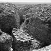
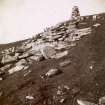
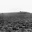
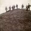
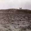
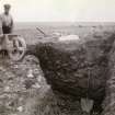
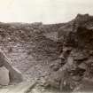
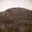
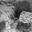
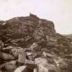
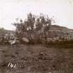
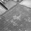
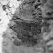
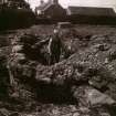
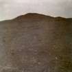
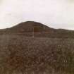
In 1940 this broch was destroyed to allow the construction of an aerodrome. Prior to this it had appeared as a grass- covered knoll about 150ft in diameter and 9ft high. It had been partially excavated in 1904 by Sir Francis Tress Barry, when only the W half of the tower was exposed. A second excavation was carried out by Calder in 1940, immediately preceding destruction.
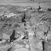
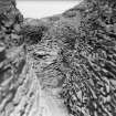
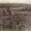
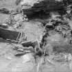
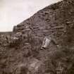
The broch had consisted of a round tower, encirled by a strong defensive rampart, with a wide, shallow ditch outside. Originally circular in shape, the tower had been built with walls some 15ft thick and an average external diameter of 62ft 6ins. The entrance had been on the W with a guard chamber built into the thickness of the wall off the S side of the passage. From the inner wall face thirteen compartments were arranged radially around the inside of the tower, the divisions consisting of thin stone slabs set on edge. Structurally it would appear that these compartments were later than the broch and possibly early improvements.
Sherds of some twenty vessels were discovered, some of them resembling pottery from the lower levels at Traprain Law. In 1904 a bone needle was also found on this site. Other relics found during the 1940 excavation include a saddle quern, several grain rubbers, dishes, knocking stones, pivot stones, anvils, tether stones, pot lids, pounders and smoothing stones, a pestle and a whorl. Also parts of circular querns of post-Roman date. Fragments of human remains found indicated an individual of rather small stature.
Finds from the 1904 excavation in the National Museum of Antiquities of Scotland (NMAS) include a bone needle (HD 431), a bone borer (HD 432), a pot (GA 908) and possibly two whorls, one of sandstone and one of steatite, donated to the NMAS in 1908.
Proc Soc Antiq Scot 1909; RCAHMS 1911; C S T Calder 1950.
There are no remains of the broch to be seen.
Revised at 1:2500.
Visited by OS (R D L) 22 April 1963.
There is no trace of this broch.
Visited by OS (J M) 14 July 1982.
Excavation (1940)
The broch was excavated by Calder in 1940, immediately preceding its removal to allow the construction of an aerodrome.
The broch had consisted of a round tower, encirled by a strong defensive rampart, with a wide, shallow ditch outside. Originally circular in shape, the tower had been built with walls some 15ft thick and an average external diameter of 62ft 6ins. The entrance had been on the W with a guard chamber built into the thickness of the wall off the S side of the passage. From the inner wall face thirteen compartments were arranged radially around the inside of the tower, the divisions consisting of thin stone slabs set on edge. Structurally it would appear that these compartments were later than the broch and possibly early improvements.
Sherds of some twenty vessels were discovered, some of them resembling pottery from the lower levels at Traprain Law. Other relics found during the 1940 excavation include a saddle quern, several grain rubbers, dishes, knocking stones, pivot stones, anvils, tether stones, pot lids, pounders and smoothing stones, a pestle and a whorl. Also parts of circular querns of post-Roman date. Fragments of human remains found indicated an individual of rather small stature.
C S T Calder 1950.
Publication Account (2007)
ND35 5 KILMSTER ('Killimster', 'Skitten') ND/3234 5655
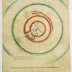
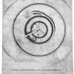
This probable solid-based broch in Wick, Caithness, used to be a grass-covered knoll about 45.75m (150ft) in diameter and 2.74m (9ft) high on flat farmland. It was partly excavated in 1904 by Sir F Tress Barry who exposed about half of the inner wallface and central court, on the western side; no report was published about this work although a plan (made by Mr John Nicholson of Nybster) was made available [2, fig. 35]. In 1940 C S T Calder spent just over two weeks rapidly but thoroughly excavating the broch before it was bulldozed to make way for Skitten aerodrome.
It is a pity that this site yielded so few finds as it was the first Caithness broch ever to have been even partly excavated in modern times and with proper care and regard to stratigraphic principles. Indeed Calder – who in this respect must be regarded as the founder of modern Iron Age archaeology in northern Scotland – was able to make many section drawings and plans despite the urgency of the work undertaken under wartime conditions. His report also includes a number of useful photographs. The sharp contrast with the situation at Crosskirk, excavated over a much longer period in the 1960s, is striking and extraordinary; no adequate section large-scale drawings are known to have been made there (Nor – judging from the report – were they at Buchlyvie in Stirlingshire, excavated even later in the 1970s ).
1. Description
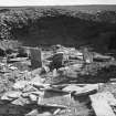
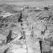
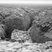
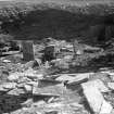
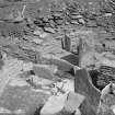
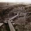
The structures consisted of the stump of a massive broch surrounded eccentrically by a wide, stone-faced rampart with a broad, shallow ditch outside this. The rampart was subsequently thickened on its inner face, and to such an extent that only a narrow passage was left between it and the broch wall [4, pl. xxviii, 3]. Only the east half of the outworks was explored but its alignment suggested that the widest part of the enclosed outer court – presumably containing outbuildings – had probably been on the west or north-west. The outer defences on the western side had been obliterated by cultivation. The main structural features were very dilapidated with 1.5-1.8m (5-6ft) of earth and rubble covering them in places.
1.1 The broch
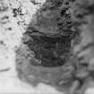
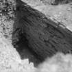
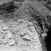
Architecture: the building survived only in Level 1, to a maximum height of 1.8m (6ft); it was only 45cm (18in) high at the entrance passage which faced west. The wall had a batter of just over 1 in 4 (35.5 in 152.5cm) on the exterior and 11 in 1 (7.5 in 81cm) on the interior: wall footings projected 30-48cm (12-19in) from below the outer face. The masonry was of high quality where freshly exposed though the sandstone slabs were thin. The only openings or spaces in the wall were the entrance passage and the guard cell which opened off its right wall; the whole of the rest of the wall was solid with no sign even of an intra-mural stair (which could of course have been in Level 2). Presumably the wall core was of stone slabs but no information on this point is given; the wall was evidently not sectioned before being bulldozed. The lowest part of the wall appears to have been well built with neatly-fitting sandstone slabs [4, pl. xxviii, 3] although it lacks the really large blocks which often occur near the foundations of these structures.
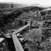
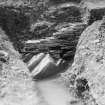
The entrance had two sets of door-checks, one 1.17m (3ft 10in) in from the outer end and the other at 2.90m (9ft 6in); they were formed of built rebates in the passage walls but only those on the north side were preserved. The passage was 91cm (3ft) wide at the exterior but varied from 84cm-102cm (2.75ft-3.5ft) at the first check and from 91-117cm (3ft- 3ft 10in) at the second. There was a bar-hole on the left behind the first set of checks but the wall behind the second set was too low for anything to be preserved there.
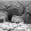
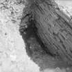
The passage had a drain running under its paved floor, 25.5-30.5cm (10-12in) wide and from 17.5-23.0cm (7-9in) deep; it had been scooped out of the natural clay subsoil. At each door-frame there was a sill stone set upright across the floor which avoided the drain; the outer kerb was 21.5cm (8.5in) high, the inner from 15-20cm (6-8in), being composed of two stones. A slab-lined socket for a hinge post was preserved behind the left check of the inner door-frame [4, pl. xxxii, 3]. The guard cell doorway was badly ruined but was probably only 60cm (2ft) wide, less than in Barry's plan. Barry described a slab-lined box set in the clay floor of the cell: only a hollow was left in 1940. The cell was about 3.0m (10ft) long by 1.63m (5ft 4in) wide: the Commission's dimens-ions ("some 15 feet" and "6ft. 6ins.") are presumably not accurate.
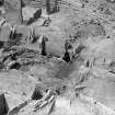
The interior: this was full of slab-built constructions such as the thirteen radial compartments, sunk pits and hearths. In some places two levels of paving could be distinguished [4, fig. 3, sections] though the original floor was probably the underlying clay layer on which the broch wall rested. Two sunk stone boxes and a deep, partly rock-cut pit (full of rubbish and peat ash) [4, fig. 3, section RS] were found below the lower paving and seem to support this idea; alternatively they could relate to a pre-broch occupation. The surviving lower paving was mostly peripheral, laid in a strip round the outer part of the court. The upper floor only overlapped it at this inner edge and this rested on blue puddled clay on 12.5cm (5in) of peat ash and covered some stone settings in which there had been post-holes. The description does not make it clear if these are stone-lined post-holes or holes inside a larger setting, nor how the drain relates to these layers of paving. The drain was open for part of its length, indicating late use, but its situation in the entrance passage strongly suggests that it was a primary feature.
The radial slabs around the interior formed several compartments in the outer part of the court; here also there was peripheral paving which could be a primary feature of the building [4, fig. 4]. One of these compartments, next to the entrance, was closed at its inner end with a high slab and others may also have been at one time. These slabs could well be secondary (because of the boxes in the clay under the paving) and the excavator surmised that not much time should have elapsed between the building of the broch and the insertion of the slab-built constructions because the latter rested right on the clay: in other words, hardly any debris had accumulated on the broch's clay floor before the slabs were set up. On the other hand, since they are linked with the peripheral paving they might well be primary features; no ring of post-holes was located at the inner edge of this paving.
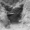
One radial compartment – no. 11 – definitely was secondary. Its back had been let 53cm (1ft 9in) into the inner face of the broch and faced with a huge upright slab. The excavator was in little doubt that this slab had been inserted [4, pl. xxviii, 2].
A large built stone fire-back stood in the centre, its long axis in line with the entrance and overlying the drain. It was 2.74m (9ft 4in). long, 76cm (30in) thick and when excavated was 38-61cm (15-24in) high; presumably its upper part had been destroyed. Two hearths, one on each side of it, were defined by a kerb and 25.5cm (10in) of peat ash covered each. There were other secondary, kerbed hearths in the interior and some had hammerstones used in their kerbs. The main entrance had been extended inwards by slabs on edge, and towards this fire-back, but one could turn left or right just before it; thus the interior was effectively divided into two halves in the secondary stage of use, almost exactly like in the secondary period of use of Midhowe in Orkney (HY33 1). Although this division of the interior into two halves seems to have occurred some time after the broch was built the ‘fire-back’ seems to rest on the primary clay floor, judging from Section RS [4, fig. 3].
A partly rock-cut pit underneath everything may have been a primary broch feature [4, pl. xxxii, 4]. It extended under the fire-back from the south side and its upper two-thirds had been deliberately filled with rubble (on top of a layer of black soil and bones), presumably when the hearth was constructed over it. The paving slabs which covered the filled-in pit appear to be part of the primary floor [4, fig. 3, section RS] so the pit may well be a pre-broch feature. One would expect such a deep hole to be analogous to the clean, deep ‘wells’ which have been found in other brochs but this one evidently served as a rubbish pit in its final period of use.
There were also 6 post-holes in the floor, 3 of them under paving. They formed no particular plan.
1.2 The outer rampart
This was 5.5-6.7m (18-22ft) thick and had a maximum height of 1.5m (5ft). It was built of a clay core revetted with facings 25-48cm (10-l9in) thick formed of battered dry stone masonry. The excavator suggested that the primary outer defence had been a simple clay rampart since there was a space, packed with rubble, between the curved surface of the clay core and the near-vertical masonry faces. Alternatively this feature may have been due to the method of construction. A ditch was in front of the wall dug into the clay and presumably provided the clay for the wall core.
A considerable extra thickness of masonry-faced rubble and clay had been added to the inner face of the outer rampart, leaving only a narrow passage around the foot of the broch wall. The core of this addition consisted of 60cm (2ft) of top soil at the bottom surmounted by 30cm (1ft) of clay with rubble on top; this is the stratigraphy of the outer ditch in reverse order and it seems to imply that the addition was formed of material from the deepened ditch. The inner edge of the addition ran round a buttress of masonry against the foot of the broch wall on the north-north-east (at 10 o'clock), so post-dated this feature.
A much thinner extra facing of masonry, of even thickness, had been added to the outer face of the broch wall anti-clockwise from the buttress to the main entrance; the excavator surmised that, since there was no damage to the broch masonry behind these two added features, they were designed to shore up the upper walls. The thin feature closely parallels the 'buttresses' at Crosskirk.
2. Discussion
Despite the cross-sections [4, fig. 3] the verbal descriptions of the internal stratigraphy of the Kilmster broch are quite brief and it is not always easy to tell which are the primary broch features and which were added later. Certainly the slab constructions, hearths and fire-back seem to be secondary, and the primary furniture of the tower probably included the drain, the central pit in the floor (if that was not older) and the peripheral paving, together with those post-holes associated with it. But the primacy of these last depends more on comparative data from other sites than from the evidence from this one.
However there is no doubt that the interior was drastically modified at some stage. The stone fire-back (in 2005, sixty-five years later, this is still an unique feature in an excavated broch) ought to be secondary (although it seems to rest on the oldest floor) and has a hearth on either side, at least one of which definitely is on the later floor [4, fig. 3, section RS]; presumably – since the only purpose of this fire-back was to cater for the two later hearths – the back itself was built in a shallow pit cut down to the oldest floor level. It was also built partly on top of the filled-in pit and may thus be indicating that the latter was indeed a primary feature, filled up when the new hearths were laid.
The interior was split into two halves by this arrangement, as at Midhowe (HY33 1), and one would like to think that the single, primary, central hearth was once where the fire-back is now, probably partly under the secondary Hearth 2. However no trace of such a feature is mentioned by the excavator.
The masonry added to the inner face of the outer rampart presents an interesting problem. If the rampart had been composed throughout of stone rubble there would have been little reason to doubt that it was the debris from the demolished upper works of the tower, such as has been observed at other sites. But the core was of topsoil and clay with stone rubble on top so it was by no means all debris from a demolished stone broch. On the other hand the buttress on the east and the secondary outer facing might be regarded as debris from such demolition, if it was once a tall tower; these features must antedate the rampart addition. Not enough evidence is available to come to definite conclusions on these matters, but it seems that two distinct secondary phases of construction and alteration occurred.
Yet another hypothesis could be constructed by assuming that the broch was, like Crosskirk not many miles away, never a tall tower; no signs of hollow-wall construction were found, and it could well be that Kilmster was also a massive, low-walled roundhouse with some broch-like features. It may even have had a clay core to its wall, as did the outer rampart, but we shall never know because the wall was not sectioned under controlled conditions but was rapidly bulldozed at the end of the excavation. The absence of really heavy blocks in the lower part of the outer face might support this idea.
The stratigraphy of the addition to the outer rampart – composed as it seems to be of material excavated from the outer ditch – is surely telling us that the site underwent an extensive, though not very thorough, re-fortification at some stage. Indeed the entire ditch is quite shallow so it may itself be a late feature, intended to be an extra protection for the surrounding wall, perhaps after the broch (if it was one) had been partly pulled down.
The material culture found in the broch (below) is remarkably impoverished when contrasted with that found in some other Caithness brochs – Crosskirk in particular. It is not clear whether this paucity of finds reflects the actual situation, or whether the conditions under which the site was excavated on two occasions made it difficult to recover all the finds.
3. Finds
Few finds were described by Calder [4].
Pottery. The few rim sherds fit reasonably well into the Orkney/Caithness jar style.
Stone. A variety of implements were found including 3 deep dishes, 4 broken upper and 1 lower rotary quern stones [4, fig. 5], 1 saddle quern, 5 pot lids, 1 long pestle, 8 hammerstones, 1 whorl and 1 polished smoother.
Those of Tress Barry's finds [2] which were given to the National Museum included a bone needle 7.5cm long, a bone borer and 2 stone whorls, 1 of sandstone and 1 of steatite.
Dimensions: external diameter 19.06m (62.5ft), internal 9.91m (32.5ft): the wall proportion is therefore 48%.
Sources: 1. NMRS site no. ND 35 NW 3: 2. Proc Soc Antiq Scot 43 (1908-09), 18 (finds): 3. RCAHMS 1911b, no. 507, pp. 146-8 and fig. 35: 4. Calder 1948: 5. Swanson (ms) 1985, 606-10.
E W MacKie 2007

