
Bute, Tarmore Hill


Cultivation Remains (Period Unassigned), Enclosure(S) (Period Unassigned), Rig And Furrow (Medieval) - (Post Medieval)
Site Name Bute, Tarmore Hill
Classification Cultivation Remains (Period Unassigned), Enclosure(S) (Period Unassigned), Rig And Furrow (Medieval) - (Post Medieval)
Canmore ID 90300
Site Number NS05NE 53
NGR NS 05136 58637
Datum OSGB36 - NGR
Permalink http://canmore.org.uk/site/90300


- Council Argyll And Bute
- Parish North Bute
- Former Region Strathclyde
- Former District Argyll And Bute
- Former County Buteshire
NS05NE 53 05136 58637
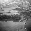
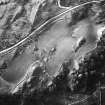
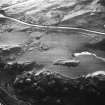
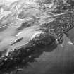
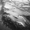
An area of rig-and-furrow, comprising several plots that have utilised natural terraces, extends across the E flank of Tarmore Hill. Some of the plots are enclosed by thick banks.
Visited by RCAHMS (LAD, GB) 2 April 2009.
Field Visit (2 April 2009)
An area of rig-and-furrow, comprising several plots that have utilised natural terraces, extends across the E flank of Tarmore Hill. Some of the plots are enclosed by thick banks.
Visited by RCAHMS (LAD, GB) 2 April 2009.

