
Bute, Craigandun


Field Boundary (Period Unassigned), Rig And Furrow (Medieval) - (Post Medieval)
Site Name Bute, Craigandun
Classification Field Boundary (Period Unassigned), Rig And Furrow (Medieval) - (Post Medieval)
Alternative Name(s) Cnoc An Duin
Canmore ID 90297
Site Number NS06SE 86
NGR NS 05190 64047
Datum OSGB36 - NGR
Permalink http://canmore.org.uk/site/90297


- Council Argyll And Bute
- Parish North Bute
- Former Region Strathclyde
- Former District Argyll And Bute
- Former County Buteshire
NS06SE 86 05190 64047
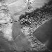
A small area of rig-and-furrow, first recorded by oblique aerial photography in 1993, is visible in rough ground 220m NW of Auchintirrie farmsteading (NS06SE 441). The plot, which measures approximately 50m square, contains at least eleven cultivation ridges measuring about 3m in breadth and orientated E and W. This area is shown as rough ground at the boundary of Auchintirrie and Dunalunt farms on two 18th century maps (Foulis 1758-9; May 1780-82).
Originally classified as an enclosure, this rig probably represents the top end of a field that was otherwise obliterated when the large improvement-period field immediately S was created in the late 18th or early 19th century.
Information from RCAHMS (GFG) 7 July 2009.
Antiquarian Mapping (1758 - 1759)
Antiquarian Mapping (1780 - 1782)
Desk Based Assessment (7 July 2009)
A small area of rig-and-furrow, first recorded by oblique aerial photography in 1993, is visible in rough ground 220m NW of Auchintirrie farmsteading (NS06SE 441). The plot, which measures approximately 50m square, contains at least eleven cultivation ridges measuring about 3m in breadth and orientated E and W. This area is shown as rough ground at the boundary of Auchintirrie and Dunalunt farms on two 18th century maps (Foulis 1758-9; May 1780-82).
Originally classified as an enclosure, this rig probably represents the top end of a field that was otherwise obliterated when the large improvement-period field immediately S was created in the late 18th or early 19th century.
Information from RCAHMS (GFG) 7 July 2009.

