
Bute, Dunagoil


Clearance Cairn(S) (Period Unassigned), Field Boundary (Period Unassigned)
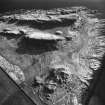
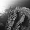
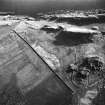
Site Name Bute, Dunagoil
Classification Clearance Cairn(S) (Period Unassigned), Field Boundary (Period Unassigned)
Canmore ID 90288
Site Number NS05SE 28
NGR NS 08694 53106
Datum OSGB36 - NGR
Permalink http://canmore.org.uk/site/90288


- Council Argyll And Bute
- Parish Kingarth
- Former Region Strathclyde
- Former District Argyll And Bute
- Former County Buteshire
NS05SE 28 08694 53106.
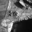
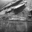
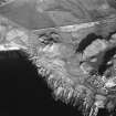
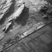
Previously interpreted as the possible remains of a structure, this feature is nothing more than a thick stony bank which is probably an old field boundary. There are several small clearance heaps in the area.
Visited by RCAHMS (AGCH, GB) 30 March 2009.
Field Visit (30 March 2009)
Previously interpreted as the possible remains of a structure, this feature is nothing more than a thick stony bank which is probably an old field boundary. There are several small clearance heaps in the area.
Visited by RCAHMS (AGCH, GB) 30 March 2009.

