
Glasgow, Glasgow Green, King's Bridge


Road Bridge (20th Century)
Site Name Glasgow, Glasgow Green, King's Bridge
Classification Road Bridge (20th Century)
Alternative Name(s) River Clyde; Ballater Street; King's Drive; Hutchesontown
Canmore ID 90267
Site Number NS66SW 901
NGR NS 60006 63771
Datum OSGB36 - NGR
Permalink http://canmore.org.uk/site/90267


- Council Glasgow, City Of
- Parish Govan (City Of Glasgow)
- Former Region Strathclyde
- Former District City Of Glasgow
- Former County Lanarkshire
NS66SW 901 60006 63771
Extends onto map sheet NS56SE.
Not to be confused with former King's Bridge (over the River Kelvin at NS c. 5735 6669), for which see NS56NE 4882.
For predecessor bridges, see NS66SW 966.
King's Bridge [NAT]
OS 1:1250 maps, 1968 and 1972.
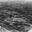
King's Bridge, Ballater Street, built 1932-3. A three-span reinforced-concrete girder bridge, with granite cutwaters and parapets.
J R Hume 1974.
King's Bridge, from King's Drive to Ballater Street, 1930-3. Engineer probably T P M Somers (City Engineer); contractor Sir Wm Arrol and Co. A bridge so flat and wide - 21m (70ft) between parapets - that one can easily cross without noticing its existence. It has four equal spans, each of eleven parallel steel girders of riveted construction, carrying a reinforced concrete road slab. The abutments and piers are of concrete, faced with smooth, fine-jointed granite, the parapet granite in simple rectilinear shapes. There are arches through the piers, showing that they are built on deep cylinders or caissons. The outsides of the external girders are encased in concrete made with fine granite aggregate, brushed or blasted to match the sawn granite of the parapets, and, to be fashionable in the 1930's, moulded to a pattern of longitudinal grooves interrupted at intervals by protruding square blocks. Unfortunately, corrosion of the reinforcement in these facings is causing spalling and staining.
E Williamson, A Riches and M Higgs 1990.
This bridge carries King's Drive (a public road) across the River Clyde between Glasgow Green (to the E) and Hutchesontown (to the W). The river here forms the boundary between the parishes of Glasgow (to the E) and Govan (to the W).
The location assigned to this record defines the centre of the span. The available map evidence indicates that the bridge extends from NS 59970 63795 to NS 60064 63732.
Information from RCAHMS (RJCM), 16 December 2005.
Construction (1930 - 1933)
Project (2007)
This project was undertaken to input site information listed in 'Civil engineering heritage: Scotland - Lowlands and Borders' by R Paxton and J Shipway, 2007.
Publication Account (2007)
This bridge, linking King’s Drive and Ballater Street with four equal spans of about 70 ft, each of 11 parallel steelplate girders supporting a reinforced concrete deck slab 70 ft between parapets, was built from 1930–33. It is a good example of best practice in ca.1930. The engineer was T. P. M. Somers, City Engineer and the contractor Sir William Arrol & Co. The cost was £113 130.
R Paxton and J Shipway 2007
Reproduced from 'Civil Engineering heritage: Scotland - Lowlands and Borders' with kind permission of Thomas Telford Publishers.

