
Bay Of Girston


Fort (Period Unassigned)(Possible)
Site Name Bay Of Girston
Classification Fort (Period Unassigned)(Possible)
Alternative Name(s) Wic 182
Canmore ID 8959
Site Number ND34NE 6
NGR ND 3636 4737
Datum OSGB36 - NGR
Permalink http://canmore.org.uk/site/8959


- Council Highland
- Parish Wick
- Former Region Highland
- Former District Caithness
- Former County Caithness
ND34NE 6 3636 4737.
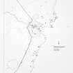
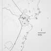
ND364 474. At the head of the Bay of Girston the land rises to a height of 150ft at the cliff edge. From the cliff edge landwards, the ground falls in a steep slope 8ft high to a flat terrace, in front of which is a V-sectioned ditch, 6ft deep, running in a slight curve for about 40 yds from edge to edge of the cliff. These features are probably the defences of a fort, most probably destroyed by the sea.
R G Lamb 1971.
ND 3636 4737. This appears to be a natural formation rather than an artificial work.
A doubtful fort.
Visited by OS 8 March 1972.
This fort was at least bivallate, if not multivallate, but nearly all of it has fallen into the sea. The V-sectioned ditch may follow a fault-line, but it appears to be artificial. It is probable that the overhanging cliff is all that remains of what was once a promontory.
R G Lamb 1980.
Natural.
C E Batey 1981.
An unusual feature, probably natural as suggested above but not conclusively so. The 'ditch' is about 45.0m long, 6.5m wide and 2.4m deep. If artificial, there is a possible causeway near the S end. The ditch does not close on the cliff at the S end, which may confirm its natural origins, or be evidence of an un finished work. The ditch is considerabaly longer than is normal in promontory forts in north Scotland. The enclosed area now measures 44.0 by 14.0m.
Surveyed at 1:2500.
Visited by OS 2 September 1982.
Field Visit (1971)
ND364 474. At the head of the Bay of Girston the land rises to a height of 150ft at the cliff edge. From the cliff edge landwards, the ground falls in a steep slope 8ft high to a flat terrace, in front of which is a V-sectioned ditch, 6ft deep, running in a slight curve for about 40 yds from edge to edge of the cliff. These features are probably the defences of a fort, most probably destroyed by the sea.
R G Lamb 1971.
Field Visit (8 March 1972)
ND 3636 4737. This appears to be a natural formation rather than an artificial work.
A doubtful fort.
Visited by OS 8 March 1972.
Project (1980 - 1982)
Field Visit (1980)
This fort was at least bivallate, if not multivallate, but nearly all of it has fallen into the sea. The V-sectioned ditch may follow a fault-line, but it appears to be artificial. It is probable that the overhanging cliff is all that remains of what was once a promontory.
R G Lamb 1980.
Field Visit (2 September 1982)
An unusual feature, probably natural as suggested above but not conclusively so. The 'ditch' is about 45.0m long, 6.5m wide and 2.4m deep. If artificial, there is a possible causeway near the S end. The ditch does not close on the cliff at the S end, which may confirm its natural origins, or be evidence of an un finished work. The ditch is considerabaly longer than is normal in promontory forts in north Scotland. The enclosed area now measures 44.0 by 14.0m.
Surveyed at 1:2500.
Visited by OS 2 September 1982.
Note (19 February 2015 - 18 May 2016)
A shallow promontory on the spectacular cliffs at the head of Girston Bay is delineated on the landward side by a ditch-like feature 6.5m broad and up to 2.4m deep, which probably follows a fault-line in the underlying rocks. The ground on the seaward side rises sharply towards the cliff-edge, but if this was ever the remains of a promontory fort, as suggested in 1971 by Raymond Lamb (1980, 76), its interior has been reduced to a narrow strip measuring about 50m from NNW to SSE by no more than 18m transversely. Subsequent investigations, including two visits by the OS and one during the Caithness Coastal Survey directed by Colleen Batey, have been less convinced that this is any more than natural, and for such a large ditch it is probably telling that no one has observed any trace of an upcast rampart.
Information from An Atlas of Hillforts of Great Britain and Ireland – 18 May 2016. Atlas of Hillforts SC2829

