Pricing Change
New pricing for orders of material from this site will come into place shortly. Charges for supply of digital images, digitisation on demand, prints and licensing will be altered.
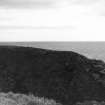
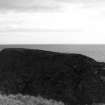
Gunn's Castle, Bulnacraig
Castle (Medieval)
Site Name Gunn's Castle, Bulnacraig
Classification Castle (Medieval)
Alternative Name(s) Lat 224
Canmore ID 8944
Site Number ND33NW 3
NGR ND 3074 3857
Datum OSGB36 - NGR
Permalink http://canmore.org.uk/site/8944
- Council Highland
- Parish Latheron
- Former Region Highland
- Former District Caithness
- Former County Caithness
ND33NW 3 3074 3857.
(ND 3074 3857) Gunn's Castle (NR) (remains of)
OS 6" map, (1971)
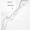
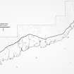
The ruins of a small rectangular keep about 37 by 23ft with walls some 3ft thick, on a peninsular rock isolated by a wall built on a rock shelf. Immediately outside the buiding at the NE angle is a circular depression, some 9ft in diameter and 2 to 3ft deep, probably indicating a well. The castle was a stronghold of the Gunns.
T Sinclair 1890; RCAHMS 1911.
The turf-covered footings of a tower, 0.5m high, known locally as 'Gunn's Castle' (information from G Sutherland, Bridgend, East Clyth, Caithness) generally as described by the RCAHMS except that the outer wall to the SW has been destroyed by erosion, and the alleged wall is probably a natural sink-hole caused by drainage through a rock fault. Date not ascertained.
Visited by OS (N K B) 10 April 1967.
Project (1980 - 1982)


