Rattar House
Chambered Cairn (Neolithic)
Site Name Rattar House
Classification Chambered Cairn (Neolithic)
Alternative Name(s) Rattar West, Dun 012
Canmore ID 8911
Site Number ND27SW 5
NGR ND 2471 7378
Datum OSGB36 - NGR
Permalink http://canmore.org.uk/site/8911
- Council Highland
- Parish Dunnet
- Former Region Highland
- Former District Caithness
- Former County Caithness
ND27SW 5 2471 7378.
(ND 2471 7378) Cairn (NR)
OS 1:10,000 map, (1976)
A conical mound of which the side nearest the sea has been eroded by the waves, exposing 'the remains of what appears to have been the entrance. It is formed of large slabs set on end. From the general outline I think it has been a chambered cairn probably divided into compartments like the rest of the Pictish Houses'.
Name Book 1873.
A low mound which has been partially carried away lies at the edge of the bank above the shelving rocks. It has a diameter of 30ft and a height of 1 1/2 to 2ft. Its character is not apparent.
RCAHMS 1911, visited 1910.
A grass-covered cairn as described by the RCAHMS. A large hole in the centre has exposed a flat stone, 1.2m long by 0.6m high, set on edge, probably the SW side stone of a cist oriented NW-SE.
Resurveyed at 1:2500.
Visited by OS (R D) 1 March 1965.
A cairn, measuring 7.2m N-S by 8.4m E-W and about 0.6m high, badly damaged, with a large flat slab, which could represent the SW side of a cist, visible in the open centre.
C E Batey 1982.
No change to the previous field report.
Visited by OS (J M) 22 April 1982.
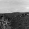
This chambered cairn is 200m NW of Rattar South (ND27SW 3), in the narrow space between the shore and a field wall, at 5m OD.
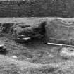
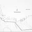
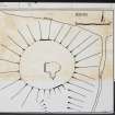
The turf-covered cairn has been about 9m in diameter, but it has been eroded by the sea on the N side and by a small burn on the E side. The edge round the Se half is vague, but a fairly clear edge remains on the W side. The cairn surface is gently rounded with a maximum height of 0.8m at the back of the chamber. The inner part of the chamber is exposed in a rectangular hollow dug to almost ground level. The chamber axis runs from a little N of E to S of W. A divisional slab on the S side is 0.4m long and 0.2m high. The back-slab, 2.1m to the W, is 1.3m long and 0.6m high. The chamber is 1.3m wide at the W end between two short lengths of wall-face, and another short length can be seen adjacent to the divisional slab. The S wall-face is interrupted by a shallower hollow extending southwards, perhaps indicating another divisional slab has been removed from this position.
J L Davidson and A S Henshall 1991, visited 3 June 1989.
Field Visit (1873)
A conical mound of which the side nearest the sea has been eroded by the waves, exposing 'the remains of what appears to have been the entrance. It is formed of large slabs set on end. From the general outline I think it has been a chambered cairn probably divided into compartments like the rest of the Pictish Houses'.
Name Book 1873.
Field Visit (1910)
A low mound which has been partially carried away lies at the edge of the bank above the shelving rocks. It has a diameter of 30ft and a height of 1 1/2 to 2ft. Its character is not apparent.
RCAHMS 1911, visited 1910.
Field Visit (1 March 1965)
A grass-covered cairn as described by the RCAHMS. A large hole in the centre has exposed a flat stone, 1.2m long by 0.6m high, set on edge, probably the SW side stone of a cist oriented NW-SE.
Resurveyed at 1:2500.
Visited by OS (R D) 1 March 1965.
Project (1980 - 1982)
Field Visit (22 April 1982)
No change to the previous field report.
Visited by OS (J M) 22 April 1982.
Field Visit (1982)
A cairn, measuring 7.2m N-S by 8.4m E-W and about 0.6m high, badly damaged, with a large flat slab, which could represent the SW side of a cist, visible in the open centre.
C E Batey 1982.
Field Visit (3 June 1989)
This chambered cairn is 200m NW of Rattar South (ND27SW 3), in the narrow space between the shore and a field wall, at 5m OD.
The turf-covered cairn has been about 9m in diameter, but it has been eroded by the sea on the N side and by a small burn on the E side. The edge round the Se half is vague, but a fairly clear edge remains on the W side. The cairn surface is gently rounded with a maximum height of 0.8m at the back of the chamber. The inner part of the chamber is exposed in a rectangular hollow dug to almost ground level. The chamber axis runs from a little N of E to S of W. A divisional slab on the S side is 0.4m long and 0.2m high. The back-slab, 2.1m to the W, is 1.3m long and 0.6m high. The chamber is 1.3m wide at the W end between two short lengths of wall-face, and another short length can be seen adjacent to the divisional slab. The S wall-face is interrupted by a shallower hollow extending southwards, perhaps indicating another divisional slab has been removed from this position.
J L Davidson and A S Henshall 1991, visited 3 June 1989.


