
Rattar


Chambered Cairn (Neolithic), Rig And Furrow (Medieval) - (Post Medieval)
Site Name Rattar
Classification Chambered Cairn (Neolithic), Rig And Furrow (Medieval) - (Post Medieval)
Alternative Name(s) Rattar South; Dun 014
Canmore ID 8905
Site Number ND27SW 3
NGR ND 2488 7366
Datum OSGB36 - NGR
Permalink http://canmore.org.uk/site/8905


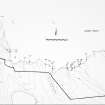

- Council Highland
- Parish Dunnet
- Former Region Highland
- Former District Caithness
- Former County Caithness
ND27SW 3 2488 7366.
(ND 2488 7366) Chambered Cairn (NR) (rems of)
OS 1:10,000 map, (1976)
The fragmentary remains of a large circular construction, from which the stones have been removed. It has probably been a broch.
RCAHMS 1911.
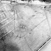
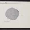
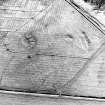
This is an Orkney-Cromary round cairn with a Camster-type chamber, which has been greatly disturbed and robbed, and is reduced to a low mound, maximum height 3ft. It now measures 80ft NW-SE by 72ft transversely. The tops of a number of thin parallel slabs can be seen projecting somewhat to the SW of the centre of the cairn, suggesting that a chamber was orientated NW-SE with the entrance at the SE. At the ESE edge of the mound are two larger slabs set more or less radially, apparently unconnected with the chamber. (Miss Henshall erroneously refers to RCAHMS site no 73 as this cairn.)
A S Henshall 1963.
The remains of this cairn are as described by Miss Henshall.
Resurveyed at 1:2500.
Visited by OS (R D) 1 March 1965.
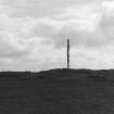
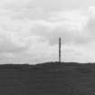
A cairn, 12.6m N-S by 11.8m E-W (sic - ? 24 by 22m) and 1m high, eroded and roughly circular. Stone slabs project and a semaphore pole is dug into the top of it.
C E Batey 1982.
The remains of a chambered cairn, generally as described.
Visited by OS (J M) 28 April 1982.
Field Visit (1911)
The fragmentary remains of a large circular construction, from which the stones have been removed. It has probably been a broch.
RCAHMS 1911.
Field Visit (1963)
This is an Orkney-Cromary round cairn with a Camster-type chamber, which has been greatly disturbed and robbed, and is reduced to a low mound, maximum height 3ft. It now measures 80ft NW-SE by 72ft transversely. The tops of a number of thin parallel slabs can be seen projecting somewhat to the SW of the centre of the cairn, suggesting that a chamber was orientated NW-SE with the entrance at the SE. At the ESE edge of the mound are two larger slabs set more or less radially, apparently unconnected with the chamber. (Miss Henshall erroneously refers to RCAHMS site no 73 as this cairn.)
A S Henshall 1963.
Field Visit (1 March 1965)
The remains of this cairn are as described by Miss Henshall.
Resurveyed at 1:2500.
Visited by OS (R D) 1 March 1965.
Project (1980 - 1982)
Field Visit (28 April 1982)
The remains of a chambered cairn, generally as described.
Visited by OS (J M) 28 April 1982.
Field Visit (1982)
A cairn, 12.6m N-S by 11.8m E-W (sic - ? 24 by 22m) and 1m high, eroded and roughly circular. Stone slabs project and a semaphore pole is dug into the top of it.
C E Batey 1982.

