
Pricing Change
New pricing for orders of material from this site will come into place shortly. Charges for supply of digital images, digitisation on demand, prints and licensing will be altered.
Rattar


Cairn (Period Unassigned)
Site Name Rattar
Classification Cairn (Period Unassigned)
Alternative Name(s) Dun 016
Canmore ID 8902
Site Number ND27SW 27
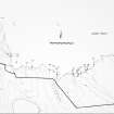
NGR ND 2495 7373
Datum OSGB36 - NGR
Permalink http://canmore.org.uk/site/8902


- Council Highland
- Parish Dunnet
- Former Region Highland
- Former District Caithness
- Former County Caithness
ND27SW 27 2495 7373.
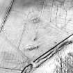
One of three mounds (the others being ND27SW 4 and ND27SE 8) shaped like inverted boats and lying in 'the Cairns Park.' They are 4' to 5' high with large stones on edge and large slabs lying flat where the soil has been rem oved. Mr Campbell (R Campbell, schoolmaster, Dunnet) sent a description to Soc Antiq Scot and Mr Anderson (?Joseph) one of the members, pronounced them to be Norse boat burials, probably dating from Earl Thorfinn's sea-battle of 1046.
Name Book 1873.
An elongated mound which appears to be natural but is considerably mutilated by cultivation.
Visited by OS 1 March 1965.
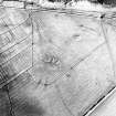
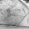
A cairn 31m by 14.7m aligned NW-SE. There has been slight erosion on the east side with walls projecting and the core of earth and small stones exp osed.
C E Batey 1982.
A mound lying along a change of slope and measuring 30m NW-SE by 15m by 0.8m high. Through the centre of the mound and continuing for much of its length is a rectangular depression suggesting an inserted structure, though it could be quarrying or cultivation. Occasional slabs show but none suggests walling.
Visited by OS 24 April 1982.
Field Visit (1873)
One of three mounds (the others being ND27SW 4 and ND27SE 8) shaped like inverted boats and lying in 'the Cairns Park.' They are 4' to 5' high with large stones on edge and large slabs lying flat where the soil has been rem oved. Mr Campbell (R Campbell, schoolmaster, Dunnet) sent a description to Soc Antiq Scot and Mr Anderson (?Joseph) one of the members, pronounced them to be Norse boat burials, probably dating from Earl Thorfinn's sea-battle of 1046.
Name Book 1873.
Field Visit (1 March 1965)
An elongated mound which appears to be natural but is considerably mutilated by cultivation.
Visited by OS 1 March 1965.
Project (1980 - 1982)
Field Visit (24 April 1982)
A mound lying along a change of slope and measuring 30m NW-SE by 15m by 0.8m high. Through the centre of the mound and continuing for much of its length is a rectangular depression suggesting an inserted structure, though it could be quarrying or cultivation. Occasional slabs show but none suggests walling.
Visited by OS 24 April 1982.
Field Visit (1982)
A cairn 31m by 14.7m aligned NW-SE. There has been slight erosion on the east side with walls projecting and the core of earth and small stones exp osed.
C E Batey 1982.

