
Scarfskerry


Broch (Iron Age)
Site Name Scarfskerry
Classification Broch (Iron Age)
Alternative Name(s) Dun 021
Canmore ID 8878
Site Number ND27SE 5
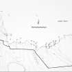
NGR ND 2564 7420
Datum OSGB36 - NGR
Permalink http://canmore.org.uk/site/8878


- Council Highland
- Parish Dunnet
- Former Region Highland
- Former District Caithness
- Former County Caithness
ND27SE 5 2564 7420.
(ND 2564 7420) Broch (NR) (site of)
OS 1:10,000 map, (1976)
The fragmentary remains of this structure are probably a broch. The building has occupied the whole of the outer end of the promontory, now some 30ft in breadth, but the crumbling away of the rock has considerably curtailed its dimensions. The whole is overgrown with grass and no part of the structure is visible. Across the landward end of the promontory a trench has been dug.
RCAHMS 1911.
The fragmentary remains of a broch, as described by the RCAHMS, except that further coastal erosion has exposed traces of walling on the N and SW sides. The ditch is now only faintly traceable.
Resurveyed at 1:2500.
Visited by OS (R B) 23 February 1965.
At least half of the broch has been eroded away but walling is visible on the N and SW, giving a wall thickness of 1.55m and an internal diameter of c.5.25m (sic).
C E Batey 1982.
The much-eroded broch now evident as a turf-covered, irregular stony mound is about 14.0m across and 1.6m high. The ditch on the landward side averages 10.0m wide and is up to 1.0m deep.
Revised at 1:2500.
Visited by OS (J B) 5 May 1982.
Field Visit (1911)
The fragmentary remains of this structure are probably a broch. The building has occupied the whole of the outer end of the promontory, now some 30ft in breadth, but the crumbling away of the rock has considerably curtailed its dimensions. The whole is overgrown with grass and no part of the structure is visible. Across the landward end of the promontory a trench has been dug.
RCAHMS 1911.
Field Visit (23 February 1965)
The fragmentary remains of a broch, as described by the RCAHMS, except that further coastal erosion has exposed traces of walling on the N and SW sides. The ditch is now only faintly traceable.
Resurveyed at 1:2500.
Visited by OS (R B) 23 February 1965.
Project (1980 - 1982)
Field Visit (5 May 1982)
The much-eroded broch now evident as a turf-covered, irregular stony mound is about 14.0m across and 1.6m high. The ditch on the landward side averages 10.0m wide and is up to 1.0m deep.
Revised at 1:2500.
Visited by OS (J B) 5 May 1982.
Field Visit (1982)
At least half of the broch has been eroded away but walling is visible on the N and SW, giving a wall thickness of 1.55m and an internal diameter of c.5.25m (sic).
C E Batey 1982.
Note (13 February 2015 - 31 May 2016)
A heavily eroded mound at the seaward end of this promontory to the SW of Scarfskerry Point is probably the remains of a broch, but there is also evidence of a ditch up to 10m broad by 1m deep cutting across the landward side on the ESE. The broch mound still stands about 1.6m high and occupies most of the interior, an area now measuring no more than 25m from ESE to WNW by 18m transversely (0.04ha), but once considerably larger. The position of the entrance is not known, and nor is the relationship between the broch and the defences cutting off the promontory.
Information from An Atlas of Hillforts of Great Britain and Ireland – 31 May 2016. Atlas of Hillforts SC2816

