
Pricing Change
New pricing for orders of material from this site will come into place shortly. Charges for supply of digital images, digitisation on demand, prints and licensing will be altered.
Cairn O' Mey, Barrogill


Cairn (Period Unassigned)
Site Name Cairn O' Mey, Barrogill
Classification Cairn (Period Unassigned)
Alternative Name(s) Barrogil, Can 022
Canmore ID 8877
Site Number ND27SE 4
NGR ND 2865 7374
Datum OSGB36 - NGR
Permalink http://canmore.org.uk/site/8877


- Council Highland
- Parish Canisbay
- Former Region Highland
- Former District Caithness
- Former County Caithness
ND27SE 4 2865 7374.
(ND 2865 7374) Cairn o' Mey (NR)
OS 1:10,000 map, (1976)
This low mound, whose character cannot be determined without excavation, lies N and S and measures some 50ft by 27ft and 2 to 3ft high. The level in the field adjacent indicates that the mound is a remnant of a larger construction which has been ploughed down.
RCAHMS 1911.
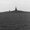
Cairn o' Mey is a large, grass-covered cairn, 0.8m high. Cultivation has reduced the size of the mound to about 14.0m in diameter, but the original limits can still be discerned, giving a diameter of some 34.0m. The central mound has been further mutilated by the erection of a monument and protection fence on its summit.
Resurveyed at 1:2500.
Visited by OS (R B) 23 February 1965.
A roughly circular, grass-covered cairn apparently reduced by ploughing and now measuring 16.5m by 7m and 1m high. It is surmounted by a stone cross, erected in 1840, and a large amount of stone is scattered about its surface.
C E Batey 1982.
Cairn o' Mey is generally as described above. Precise measurement is impossible owing to incursion by ploughing and the erection of the monument. The protection fence has been removed.
Revised at 1:2500.
Visited by OS (J B) 5 May 1982.
Field Visit (1911)
This low mound, whose character cannot be determined without excavation, lies N and S and measures some 50ft by 27ft and 2 to 3ft high. The level in the field adjacent indicates that the mound is a remnant of a larger construction which has been ploughed down.
RCAHMS 1911.
Field Visit (23 February 1965)
Cairn o' Mey is a large, grass-covered cairn, 0.8m high. Cultivation has reduced the size of the mound to about 14.0m in diameter, but the original limits can still be discerned, giving a diameter of some 34.0m. The central mound has been further mutilated by the erection of a monument and protection fence on its summit.
Resurveyed at 1:2500.
Visited by OS (R B) 23 February 1965.
Project (1980 - 1982)
Field Visit (5 May 1982)
Cairn o' Mey is generally as described above. Precise measurement is impossible owing to incursion by ploughing and the erection of the monument. The protection fence has been removed.
Revised at 1:2500.
Visited by OS (J B) 5 May 1982.
Field Visit (1982)
A roughly circular, grass-covered cairn apparently reduced by ploughing and now measuring 16.5m by 7m and 1m high. It is surmounted by a stone cross, erected in 1840, and a large amount of stone is scattered about its surface.
C E Batey 1982.

