
Bute, Achavoulaig


Enclosure (Period Unassigned)
Site Name Bute, Achavoulaig
Classification Enclosure (Period Unassigned)
Alternative Name(s) Cromchlar Butt, Cromachan Park
Canmore ID 88726
Site Number NS06NW 69
NGR NS 0219 6865
Datum OSGB36 - NGR
Permalink http://canmore.org.uk/site/88726

- Council Argyll And Bute
- Parish North Bute
- Former Region Strathclyde
- Former District Argyll And Bute
- Former County Buteshire
NS06NW 69 025 685.
Survey of deserted settlements, Isle of Bute: All sites are being measured and photographed, although a considerable number have still to be visited. To maintain uniformity a record form is completed for each site, with a brief description, including an indication of the reliability of the information. Air photographs (courtesy NMRS) have been used to locate many sites. Others have been identified only on early maps, (courtesy the Bute Estate Office). Research of documentary records, such as the Statute Labour Lists, Hearth Tax, Census Data, has generated considerable additional information, including family names, date of foundation or desertion. Information is uneven, because records are not equally available for all areas.
The majority of the settlements are post-medieval farm sites. Of several anomalous remains, some are earlier, while others, because of location and form are unlikely to be domestic structures.
The records are held in the Bute Museum, The basic list has been forwarded to NMRS.
Sponsors: Bute Antiq Natur Hist Soc; St Andrews Heritage Services.
Hannah and Proudfoot 1994.
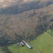
There is no evidence on maps and estate plans, including Roy (1747-55) and May (1780-2), that a farmstead or any other form of settlement existed on or around the present farmsteading of Achavoulaig (NS06NW 100) before about the middle of the 19th century. A source for the name ‘Cromchlar Butt' is not provided by the previous authority, but a large enclosure called 'Cromachan Park' (centred on NS 0219 6865) is depicted here on Mackinlay's map of North Bute (1823). That map shows that the original farmstead of Achavolaig (NS06NW 70) stood some 415 NW of the present steading.
Visited by RCAHMS (GFG, PJD) 22 March 2009.
Antiquarian Mapping (1823)
Desk Based Assessment (22 March 2009)
There is no evidence on maps and estate plans, including Roy (1747-55) and May (c 1780), that a farmstead or any other form of settlement existed on or around the present farmsteading of Achavoulaig before about the middle of the 19th century. A source for the name ‘Cromchlar Butt' is not provided by the previous authority, but a large enclosure called 'Cromachan Park' (centred on NS 0219 6865) is depicted here on Mackinlay's map of North Bute (1823). That map shows that the original farmstead (NS06NW 70) stood some 415 NW of the present steading.
Visited by RCAHMS (GFG, PJD) 22 March 2009.

