
Pricing Change
New pricing for orders of material from this site will come into place shortly. Charges for supply of digital images, digitisation on demand, prints and licensing will be altered.
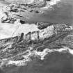
Scarfskerry, Harbour


Harbour (Period Unassigned)
Site Name Scarfskerry, Harbour
Classification Harbour (Period Unassigned)
Alternative Name(s) The Haven, Scarfskerry
Canmore ID 8872
Site Number ND27SE 17
NGR ND 2602 7449
Datum OSGB36 - NGR
Permalink http://canmore.org.uk/site/8872


- Council Highland
- Parish Dunnet
- Former Region Highland
- Former District Caithness
- Former County Caithness
ND27SE 17 2602 7449
(Location cited as ND 260 745). The Haven, Scarfskerry. A natural rift in the local flagstone reefs, with a modern concrete jetty. Nearby is a small single-storey storehouse.
J R Hume 1977.

