
Bute, Etterick Village


Dam (Period Unassigned), Inn (Period Unassigned), Smithy(S) (Period Unassigned), Village (Period Unassigned), Watermill (Period Unassigned)
Site Name Bute, Etterick Village
Classification Dam (Period Unassigned), Inn (Period Unassigned), Smithy(S) (Period Unassigned), Village (Period Unassigned), Watermill (Period Unassigned)
Canmore ID 88712
Site Number NS06NW 66
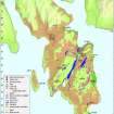
NGR NS 03942 66650
Datum OSGB36 - NGR
Permalink http://canmore.org.uk/site/88712


- Council Argyll And Bute
- Parish North Bute
- Former Region Strathclyde
- Former District Argyll And Bute
- Former County Buteshire
NS06NW 66 03942 66650.
Recorded during survey of deserted settlements; records are held in the Bute Museum.
Sponsor: Bute Antiq Natur Hist Soc; St Andrews Heritage Services.
Hannah and Proudfoot 1994.
NS 038 665. Ettrick Smithy: platform.
A C Hannah and E V W Proudfoot 1995
A farmstead, comprising one roofed, one unroofed building and one enclosure is depicted on the 1st edition of the OS 6-inch map Argyllshire and Buteshire {Island of Bute} 1869, sheet cciii), but it is not shown on the OS 1:10000 map (1980). The farmstead noted may be the mill located by Hannah and Proudfoot (1994).
Information from RCAHMS (AKK) 4 June 1999.
NS 039 666 Site 143 Ettrick Village
In the early 19th century this village included a mill (in record from 1616), a public house and two smithies. All that remains are the traces of a platform and the course of a lade and three clapper bridges. By 1863, only one building remained in occupation (OS1)
Proudfoot and Hannah 2000
NS 0391 6661 Part of deserted village remains: Located on N bank of Mid Colmac Burn, 100m downstream from mill. There is a large level platform between present burn and its former course at foot of steep bank. Possible remains of a building obscured by many heaps of stone dumped on and around it. SROK shows 2 smiddies on site, c.1810.
Information from Bute Natural History Society Deserted Settlement Survey (1991-9)
(RCAHMS WP000273)
NS 0392 6662 Part of deserted village remains: Located on N bank of Mid Colmac Burn, 180m NE of junction of Glenmore road with B845. There are the traces of an old track. Burn in 15m stone culvert, with large cover stones (clapper bridge). There are no visible remains of building or dam. This site was in record from 1616. SROK shows a building and mill dam, c.1810.
Information from Bute Natural History Society Deserted Settlement Survey (1991-9)
(RCAHMS WP000273)
Nothing is visible of this village, which stood about 180m SW of Etterick Smithy (NS06SW 86), in what is now improved pasture on the NW side of an un-named stream.
'Ettrick Mill' is first depicted on Roy's Military Map (1747-55) and, in more detail, on an early-19th century estate map (RHP14262). Another map of North Bute shows as many as eight buildings here, including a smithy, a public house, Etterick mill and a school (Mackinlay 1823).
By 1863, only one roofed building survived (Buteshire 1869, Sheet CCIII), and it had been removed by 1896 (Buteshire 1897, Sheet CCIII.NE).
Visited by RCAHMS (GFG, PJD) 22 April 2009.
Antiquarian Mapping (1747 - 1755)
Antiquarian Mapping (1823)
Field Visit (1991 - 1999)
NS 0392 6662 Part of deserted village remains: Located on N bank of Mid Colmac Burn, 180m NE of junction of Glenmore road with B845. There are the traces of an old track. Burn in 15m stone culvert, with large cover stones (clapper bridge). There are no visible remains of building or dam. This site was in record from 1616. SROK shows a building and mill dam, c.1810.
Information from Bute Natural History Society Deserted Settlement Survey (1991-9)
(RCAHMS WP000273)
Field Visit (1991 - 1999)
NS 038 665. Ettrick Smithy: platform.
A C Hannah and E V W Proudfoot 1995
NS 0391 6661 Part of deserted village remains: Located on N bank of Mid Colmac Burn, 100m downstream from mill. There is a large level platform between present burn and its former course at foot of steep bank. Possible remains of a building obscured by many heaps of stone dumped on and around it. SROK shows 2 smiddies on site, c.1810.
Information from Bute Natural History Society Deserted Settlement Survey (1991-9)
(RCAHMS WP000273)
Field Visit (22 April 2009)
Nothing is visible of this village, which stood about 180m SW of Etterick Smithy (NS06SW 86), in what is now improved pasture on the NW side of an un-named stream.
'Ettrick Mill' is first depicted on Roy's Military Map (1747-55) and, in more detail, on an early-19th century estate map (RHP14262). Another map of North Bute shows as many as eight buildings here, including a smithy, a public house, Etterick mill and a school (Mackinlay 1823).
By 1863, only one roofed building survived (Buteshire 1869, Sheet CCIII), and it had been removed by 1896 (Buteshire 1897, Sheet CCIII.NE).
Visited by RCAHMS (GFG, PJD) 22 April 2009.
Antiquarian Mapping

