
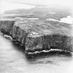
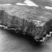
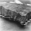
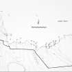
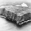
Easter Head, Dunnet Head


Cairn (Period Unassigned)
Site Name Easter Head, Dunnet Head
Classification Cairn (Period Unassigned)
Alternative Name(s) Dun 001
Canmore ID 8859
Site Number ND27NW 1
NGR ND 2054 7650
Datum OSGB36 - NGR
Permalink http://canmore.org.uk/site/8859


- Council Highland
- Parish Dunnet
- Former Region Highland
- Former District Caithness
- Former County Caithness
ND27NW 1 2054 7650
(ND 2054 7650) Cairn (NR)
OS 1:10,000 map, (1975)
This is a small cairn of low elevation with a diameter of approximately 16ft. A surveyor's cairn has been erected on the top.
RCAHMS 1911, visited 1910.
The much mutilated, grass-covered remains of this cairn survive to a maximum height of 1.5m and measure some 12.0m in diameter. The cairn has been flattened on top where a modern concrete building has been built. Resurveyed at 1:2500.
Visited by OS (R B), 23 May 1965.
This roughly circular cairn, 12m in diameter and about 1m high, has been badly damaged within the last two years by the superimposition of a 'scenic viewpoint'.
C E Batey 1982 (see archive).
A cairn as described above.
Visited by OS (N K B), 19 May 1982.
Field Visit (23 May 1965)
The much mutilated, grass-covered remains of this cairn survive to a maximum height of 1.5m and measure some 12.0m in diameter. The cairn has been flattened on top where a modern concrete building has been built. Resurveyed at 1:2500.
Visited by OS (R B) 23 May 1965.
Project (1980 - 1982)
Field Visit (19 May 1982)
A cairn as described above.
Visited by OS (N K B) 19 May 1982.

