Pricing Change
New pricing for orders of material from this site will come into place shortly. Charges for supply of digital images, digitisation on demand, prints and licensing will be altered.
Upper Bowertower, Stone Lud
Cairn (Prehistoric), Standing Stone(S) (Prehistoric)
Site Name Upper Bowertower, Stone Lud
Classification Cairn (Prehistoric), Standing Stone(S) (Prehistoric)
Canmore ID 8852
Site Number ND26SW 3
NGR ND 22171 61739
Datum OSGB36 - NGR
Permalink http://canmore.org.uk/site/8852
- Council Highland
- Parish Bower
- Former Region Highland
- Former District Caithness
- Former County Caithness
ND26SW 3 221 617.
(ND 2217 6174) Stone Lud (NR) (ND 2216 6174) Cairn (NR) (ND 2218 6171) Stone (NAT)
OS 6" map, (1970)
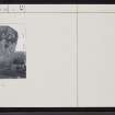
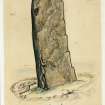
'Stone Lud' is a standing stone, 8ft 6ins high, 3ft to 3ft 8ins broad and 1ft 9ins thick. It is frequently suggestsed that this stone marks the grave of Liot, one of the Orkney Earls, who was mortally wounded in the battle with the Scots at Skida Mire (ND15SE 12) between 943 and 945, but other than the slight resemblance of the names, there is no warrant for the suggestion.
Another stone similar to, and possibly associated with, Stone Lud lies prostrate about 96ft to the SSE. It measures 8ft 3ins long, 3ft 10ins to 4ft 10ins broad and 10ins thick.
A small cairn, 26ft in diameter and 1ft in height, lies about 23ft NW of Stone Lud. It has been excavated.
RCAHMS 1911, visited 1910
'Stone Lud', the possibly associated prostrate stone, and the small cairn are as described by the RCAHMS. Around the prostrate stone is a grass-covered oval enclosure measuring 5.0m by 4.0m, the purpose of which could not be ascertained.
Resurveyed at 1:2500.
Visited by OS (N K B) 29 October 1965
'Stone Lud' is as described above. The small cairn exhibits no cist, chamber or kerb and the previous excavation has become filled by soil and vegetation. The prostrate stone, though partially turf-covered appears to be 3.5m in full length. The 'enclosure' noted by previous OS field investigator is possibly the result of crude excavation around the fallen stone.
Revised at 1:2500.
Visited by OS (J B) 6 May 1982
Standing Stone (ND 2222 6172), 'Stone Lud'. Height: 2.59m. The stone is 1.14m wide and 0.49m thick at base, leaning with the prevailing wind, in an area surrounded by thick grass and reeds. A prostrate stone lies in a small depression SSE of the standing stone. It is 1.48m wide at the base and 1.96m long. The associated cairn is sub-circular, measuring 8.5 x 9m.
R J Mercer, NMRS MS/828/19, 1995
Field Visit (29 June 1910)
Situated at the side of a stone wall on the moorland, about 1 m WSW of Bower Church, is a high standing-stone (RCAHMS 1911 pl. 1) bearing the name of Stone Lud’. It measures 8' 6" [2.6m] in height above ground, 3' 8" [1.1m] in breadth at base, about 3' [0.9m] in breadth near its upper extremity, and 1' 9" in thickness. It is set facing almost ENE. and WSW. Some 96' to the SSE. is a similar stone, lying prostrate, which seems to have stood in the same alignment. It measures 8' 3" in length [2.5m], 4' 10" in breadth at base, 3' 10"in breadth at its upper end, and 10" in thickness. Some 23' to the NW. of the upright stone is a small cairn, with a diameter of 26', which has been excavated. Its elevation is now about 1'. The erect standing-stone is frequently referred to in print, and the suggestion made that ‘Lud’ is a corruption of ‘Liot’, the name of one of the Orkney Earls who was mortally wounded in a battle with the Scots at Skida Mire, and is supposed to have been buried here, but there is no other warrant for the suggestion than the slight resemblance of the names. As no reference exists to the prostrate stone it has evidently been long in its present position.
See CaIder's Caithness, p. 52; Stat. Acct., vii. p. 521.
RCAHMS 1911, visited 29 June 1910
OS 6” map (1907)


