
Links Of Greenland


Cairn(S) (Period Unassigned)
Site Name Links Of Greenland
Classification Cairn(S) (Period Unassigned)
Canmore ID 8829
Site Number ND26NW 4
NGR ND 218 693
Datum OSGB36 - NGR
Permalink http://canmore.org.uk/site/8829


- Council Highland
- Parish Dunnet
- Former Region Highland
- Former District Caithness
- Former County Caithness
ND26NW 4 218 693.
(ND 2180 6932 & ND 2182 6932) Cairns (NR)
OS 1:10,000 map, (1975)
Two small cairns about 32ft in diameter and 5 to 6ft high. Neither appears to have been excavated.
RCAHMS 1911, visited 1910.
Two sand and turf covered cairns as described by the RCAHMS. The one in the E has a loose flat slab, 0.9m by 0.6m, lying prostrate on its E arc.
Visited by OS (I S S) 9 March 1972.
As described by the previous authorities, except that there is some evidence that trenching has taken place across both features. Though they have a regular plan and profile which is cairn-like, they are situated in a dune landscape and may be small circular dunes. Rabbit scrapes in the summit indicate pure sand only; the sole evidence for a stony content is the aforementioned flat slab at the base of the E mound.
Revised at 1:10,000.
Visited by OS (N K B) 7 July 1982.
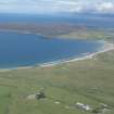
Field Visit (July 2008 - August 2008)
ND 218 690 Between July and August 2008 an ambitious archaeological community programme began in and around Dunnet Bay. The project aimed to encourage local people to engage with their heritage; to use their archaeology and history to enhance community and cultural identity; and to appreciate the cultural and natural resources of the area. Archaeological training in a range of techniques was central to all aspects of the work.
Working with AOC Archaeology Group a six week programme was formulated that included: survey, fieldwork,
post-excavation, weekend workshops, evening lectures, schools workshops, a daily website, open days, posters and press releases. The aim was to engage as much of the community as possible.
Fieldwork was a central component of the project, and the programme combined community training with an
assessment of the archaeological deposits in and around Dunnet Bay. The study area covered c5km2. Known
archaeology included chambered cairns, brochs, medieval buildings, a Viking grave and a possible Viking settlement. The fieldwork aimed to augment these findings and locate, characterise and define the extent of other possible human activity, with a particular focus on the Viking and Late Norse/medieval periods. Survey incorporated fieldwalking, EDM survey, 3D laser scanning and a programme of coring.
A small-scale evaluation excavation was also undertaken, focussing on two of the primary areas identified through survey. Both were in the northern area of the bay, close to a possible Norse settlement. In one of the trenches a putative wall associated with anthropogenic soils was recorded. Post-excavation analysis will concentrate on assessing the nature and date of these deposits. Following the successful training
programme the area will continue to be mapped by the local community. Grateful thanks to Heritage Lottery Fund for sponsoring the project and to the local community for all their effort and support.
Archive: RCAHMS (intended)
Funder: Heritage Lottery Fund
Andrew Heald (Castletown Heritage Society / AOC Archaeology Group), 2008

