|
Photographs and Off-line Digital Images |
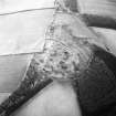
SE 1279 |
RCAHMS Aerial Photography |
Oblique aerial view. |
1982 |
Item Level |
|
|
Photographs and Off-line Digital Images |
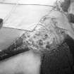
SE 1280 |
RCAHMS Aerial Photography |
Oblique aerial view. |
1982 |
Item Level |
|
|
Photographs and Off-line Digital Images |
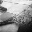
SE 1281 |
RCAHMS Aerial Photography |
Oblique aerial view. |
1982 |
Item Level |
|
 |
On-line Digital Images |
SC 1738602 |
RCAHMS Aerial Photography |
Oblique aerial view. |
1982 |
Item Level |
|
 |
On-line Digital Images |
SC 1738603 |
RCAHMS Aerial Photography |
Oblique aerial view. |
1982 |
Item Level |
|
 |
On-line Digital Images |
SC 1738604 |
RCAHMS Aerial Photography |
Oblique aerial view. |
1982 |
Item Level |
|
 |
On-line Digital Images |
SC 2620196 |
Records of the Ordnance Survey, Southampton, Hampshire, England |
Torwoodlee, NT43NE Lin 528, Ordnance Survey Index Card, Recto |
c. 1958 |
Item Level |
|
 |
On-line Digital Images |
SC 2620200 |
Records of the Ordnance Survey, Southampton, Hampshire, England |
Torwoodlee, NT43NE Lin 528, Ordnance Survey Index Card, Recto |
c. 1958 |
Item Level |
|
|
All Other |
551 166/1/1 |
Records of the Ordnance Survey, Southampton, Hampshire, England |
Archaeological site card index ('495' cards) |
1947 |
Sub-Group Level |
|


