
Ballinloan Burn


Building(S) (Medieval) - (Post Medieval), Cairnfield (Medieval) - (Post Medieval), Field System (Medieval) - (Post Medieval), Hut(S) (Medieval) - (Post Medieval), Mound (Period Unknown), Rig And Furrow (Medieval) - (Post Medieval)
Site Name Ballinloan Burn
Classification Building(S) (Medieval) - (Post Medieval), Cairnfield (Medieval) - (Post Medieval), Field System (Medieval) - (Post Medieval), Hut(S) (Medieval) - (Post Medieval), Mound (Period Unknown), Rig And Furrow (Medieval) - (Post Medieval)
Canmore ID 87687
Site Number NN94SW 25
NGR NN 9392 4240
Datum OSGB36 - NGR
Permalink http://canmore.org.uk/site/87687


- Council Perth And Kinross
- Parish Little Dunkeld
- Former Region Tayside
- Former District Perth And Kinross
- Former County Perthshire
Field Visit (7 December 1993)
NN94SW 25 9392 4240
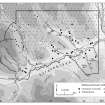
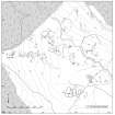
Situated on, and around, a knoll overlooking the valley of the Ballinloan Burn, there is a group of turf huts, two buildings, a field-system, a patch of rig and a few small cairns. A sheepfold and a later stone dyke ovelie the SE part of the site.
Of the two buildings, one (Braan93 210), which lies immediately E of the summit of the knoll and overlies the line of a field-bank, measures 11.2 from N to S by 6.2m transversely over turf and stone walls spread to 2.5m in thickness and 0.3 in height. The other (Braan93 232), also overlying a field-bank, measures 13.5 from E to W by 5.8m transversely over a stony bank spread to 1.5m in thickness and 0.2m in height, with an entrance in the S.
Most of the eleven huts (Braan93 233-243) are grouped on the top of the knoll and are set against, or built over, the banks of the field-system. Four are of mounded turf, and range in size from 4.1m to 6.5m in length by between 3.6m and 5m in breadth and stand up to 0.5m in height. Others are built of turf and stone and range in size from 4m to 8.2m by between 3m and 6.2m in breadth over walls reduced to between 0.2m and 0.5m in height and between 1m and 2m in thickness.
The field-system is made up of earthen dykes, enclosing subrectangular fields, each of about 0.25ha to 0.5ha in extent, and totalling in excess of 4ha. Rig, which runs across the contour, is visible in one of the fields. In others there are traces of lynchets built up against some of the banks where they run across the slope, indicating cultivation, even where rig is not visible. At the SE of the site, and to the SE of the dyke in deep heather, there are a few small cairns and the field-banks appear to be more fragmentary. An earthen mound, about 7m across and 1m high, occupies the summit ot the knoll; its function is uncertain.
(Braan93 210, 232-243, 450)
Visited by RCAHMS (PJD) 7 December 1993

