
Ballinloan Burn


Building(S) (Early Medieval) - (Post Medieval), Cairnfield (Medieval) - (Post Medieval), Field Boundary(S) (Medieval) - (Post Medieval), Field System (Medieval) - (Post Medieval)(Possible), Rig And Furrow (Medieval) - (Post Medieval)
Site Name Ballinloan Burn
Classification Building(S) (Early Medieval) - (Post Medieval), Cairnfield (Medieval) - (Post Medieval), Field Boundary(S) (Medieval) - (Post Medieval), Field System (Medieval) - (Post Medieval)(Possible), Rig And Furrow (Medieval) - (Post Medieval)
Canmore ID 87686
Site Number NN94SW 24
NGR NN 9352 4294
Datum OSGB36 - NGR
Permalink http://canmore.org.uk/site/87686


- Council Perth And Kinross
- Parish Little Dunkeld
- Former Region Tayside
- Former District Perth And Kinross
- Former County Perthshire
Field Visit (6 December 1993)
NN94SW 24 9352 4294
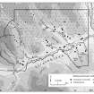
On a spur of the E-facing hillslope to the SW of the Ballinloan Burn, there are two buildings, a spread of small cairns, numerous banks, a field-system, a head-dyke and a patch of rig. The site extends for 650m from WNW to ESE by up to 200m transversely and is bounded on three sides by wet or boggy ground.
The two buildings, which are situated on a terrace at the top of a patch of rig, are poorly preserved. The N building (Braan93 208) is bow-sided, measures 11m from N to S by 5.6m transversely over stony banks 1.5m thick and 0.3m high and has an entrance in the E, the second building (Braan93 209), which is less well preserved, incorporates a large boulder and clearance on its N side, and measures 11.5m from E to W by 6.4m transversely over low stony banks spread to 1.4m in thickness and 0.25m in height.
On the slope below the buildings there are the remains of a field-system, including the vestiges of rig and few small cairns, some of which are aligned with the rig and may belong to this episode of cultivation. The rig, 4.5m in width, runs downslope from WSW to ENE, parallel with a bank of the field-system to the N. At the head of the field-system the remains of a dyke can be traced across the spur from N to S, but it stops short of the buildings. Above and to the W of this dyke the spread of small cairns and banks extends for some 300m. The small cairns vary considerably in size with the largest about 6m across by up to 0.75m in height. The banks vary from substantial cleared boulders to rickles of stones, and in places there are lynchets where the banks run across the spur (NN 9333 4300); indeed, these may be the vestiges of a series of plots (about 30m across) running down the spur.
(Braan93 207-9)
Visited by RCAHMS (PJD) 6 December 1993

