
Ballinloan Burn


Cairnfield (Prehistoric), Field System (Prehistoric)
Site Name Ballinloan Burn
Classification Cairnfield (Prehistoric), Field System (Prehistoric)
Canmore ID 87685
Site Number NN94SW 23
NGR NN 9305 4300
Datum OSGB36 - NGR
Permalink http://canmore.org.uk/site/87685

- Council Perth And Kinross
- Parish Little Dunkeld
- Former Region Tayside
- Former District Perth And Kinross
- Former County Perthshire
Field Visit (6 December 1993)
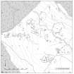
NN94SW 23 9305 4300
On the E-facing slope of the hillside to the SW of the Ballinloan Burn, immediately S of a forestry plantation, there is a group of strip fields and a few small cairns. The strip-fields extend over an area of about 100m from NE to SW by 50m transversely. The strips run downslope and are defined by sinuous, low stony banks, measuring about 50m in length by 5m in breadth. The majority of the small cairns lie to the NW of the strips. (Braan93 206)
Visited by RCAHMS 6 December 1993

