
Pricing Change
New pricing for orders of material from this site will come into place shortly. Charges for supply of digital images, digitisation on demand, prints and licensing will be altered.
Ballentuim


Farmstead (Post Medieval), Field Boundary(S) (Post Medieval), Kiln Barn (Post Medieval)
Site Name Ballentuim
Classification Farmstead (Post Medieval), Field Boundary(S) (Post Medieval), Kiln Barn (Post Medieval)
Canmore ID 87234
Site Number NN94SE 15
NGR NN 9907 4114
NGR Description centred on NN 990 411
Datum OSGB36 - NGR
Permalink http://canmore.org.uk/site/87234


- Council Perth And Kinross
- Parish Little Dunkeld
- Former Region Tayside
- Former District Perth And Kinross
- Former County Perthshire
Field Visit (24 November 1993)
NN94SE 15 990 411
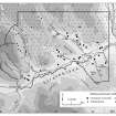
This farmstead is situated on a SSE-facing hillside above the River Braan, some 120m NNW of the remains of Lagganalachie Church (NN94SE 3). It is one of two steadings to which the name 'Ballentuim' is applied on the 1st edition of the OS 6-inch map (Perthshire 1867, sheet lxi), the other being some 200m to the ENE (NN94SE 16). The remains comprise at least two buildings, a kiln and three small enclosures. The two buildings are depicted as roofed on the 1st edition of the OS 6-inch map (ibid). Standing a few metres apart, they are both aligned along the contour, end-on to each other, and each have an enclosure attached on the NNW side. That to the WSW measures 21.4m in length and 4.5m in breadth internally (Braan93 264), while that to the ENE (Braan93 263) measures 16.6m in length and 4.2m in breadth. The walls of both buildings are of faced rubble, up to 0.75m thick with squared corners. They were both entered through the SSE side wall, and both are divided into two compartments. There is a fireplace in the WSW building (Braan93 264), which also has an outshot, 5.5m in length, attached to its WSW end. To the SE of the ENE building (Braan93 263) is a possible third building (Braan93 262), shown roofless on the 1st edition map, consisting of a rectangular stance set into the slope, its long axis lying NNW-SSE, at right angles to the contour. It measures 12.2m in length and 5.5m in breadth, but only the SSE end, where some facing stones are visible, is well defined. About 20m to the SW of this platform there is a kiln (Braan93 265), set into the slope, with a barn attached on its SSE side. Kiln and barn together measure 6.8m in length by 4.2m in breadth over walls spread to 1.2m in thickness. Only occasional inner facings of the kiln bowl are visible. The kiln is not depicted on the 1st edition map (ibid).
(Braan93 263-5)
Visited by RCAHMS (SDB) 24 November 1993

