
Newton Of Ballinloan


Building (Medieval) - (Post Medieval), Settlement (Early Medieval)
Site Name Newton Of Ballinloan
Classification Building (Medieval) - (Post Medieval), Settlement (Early Medieval)
Canmore ID 87233
Site Number NN94SE 14
NGR NN 9777 4058
Datum OSGB36 - NGR
Permalink http://canmore.org.uk/site/87233


- Council Perth And Kinross
- Parish Little Dunkeld
- Former Region Tayside
- Former District Perth And Kinross
- Former County Perthshire
Field Visit (9 December 1993)
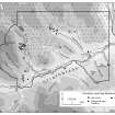
NN94SE 14 9777 4058
The remains of what appears to have been a homestead overlain by a later building are situated in a cultivated field on sloping ground above the N bank of the River Braan, about 140m WNW of Newton Bridge. It comprises a sub-circular enclosure, levelled into the S-facing hillside, which measures about 17.5m in diameter over a faced-rubble wall 1.8m in thickness and standing up to 0.5m high. A gap, 2.9m wide, on the SSW indicates the probable position of the entrance. The wall has been extensively robbed; ploughing has obliterated it on the N and E, and a later building, aligned approximately N-S and itself robbed, overlies the SE quadrant.
(Braan93 430)
Visited by RCAHMS (SDB) 9 December 1993

