
Salachill


Cruck Framed Building(S) (Post Medieval), Township (Post Medieval)
Site Name Salachill
Classification Cruck Framed Building(S) (Post Medieval), Township (Post Medieval)
Alternative Name(s) Ballinloan Burn
Canmore ID 86526
Site Number NN94SE 13
NGR NN 955 424
NGR Description Centred on NN 955 424
Datum OSGB36 - NGR
Permalink http://canmore.org.uk/site/86526


- Council Perth And Kinross
- Parish Little Dunkeld
- Former Region Tayside
- Former District Perth And Kinross
- Former County Perthshire
Field Visit (28 October 1993)
NN94SE 13.00 centred on 955 424
NN94SE 13.01 NN 9541 4271 Farmstead
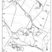
The remains of this township are situated on the SW-facing hillside above the NE bank of the Ballinloan Burn, about 2.7km upstream from Ballinloan Bridge. Most of the remains are concentrated in an area of about 5ha, in which there are at least twenty-three buildings, many of them grouped into farmsteads, linked by trackways and set within stone-walled fields scattered with field-clearance heaps. About 250m to the NNW of this concentration there is a fifth farmstead, abandoned but still partly roofed, which appears to be of later date (NN94SE 13.01). The 1st edition of the OS 6-inch map (Perthshire 1867, sheet lxi) depicts almost all of these buildings (20 unroofed buildings), although only two (at NN94SE 13.01) are shown roofed.
Within the main area of settlement four farmsteads can be identified, each comprising five or six buildings loosely clustered around an irregularly-shaped yard. Two of these are located on a terrace immediately above the Ballinloan Burn, at NN 9542 4234 (Braan3 96-100) and NN 9547 4233 (Braan93 101-6), while the other two are situated on the hillside to the NE at NN 9553 4244 (Braan93 109-13) and NN 9556 4248 (Braan93 114-118). Only two buildings do not fit easily into any of these groups (Braan93 107 and 108); they stand in isolation at the W edge of the site at NN 9545 4240 and NN 9544 4245 respectively.
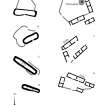
The buildings are all broadly similar in construction: roughly rectangular with square corners and in most cases gable-ended, they have faced-rubble walls mostly measuring between 0.6m and 0.75m in thickness, and cruck slots are visible in a few cases. Many of them are set into the hillside, or terraced up on their downhill side. On the basis of their size the buildings can be divided into two distinct groups. In the first group there are five buildings measuring internally between 20.3m and 29.5m in length and between 3.8m and 4.5m in breadth. There is one of these long buildings in each farmstead, always on the N side of the yard (Braan93 96, 103, 112 and 116) while the fifth is one of the two isolated buildings at the W edge of the site (Braan93 107). They are all divided into two or more compartments and most of the compartments have separate entrances, which in all cases are in the S side wall, opening onto the yard. Two of these buildings have fireplaces (Braan93 103, 116), in both cases in the W gable, while running the length of the E compartment in buildings (Braan93 103 and 112) there is a central drain, indicating use as a byre.
The other eighteen buildings measure internally between 5.2m and 14.3m in length, and between 2.5m and 4.4m in breadth. Most of them are clustered close to the larger buildings, and serve to define, at least in part, the limits of each steading's yard. Several of the larger examples are divided into two compartments, and there is evidence of an upper floor in at least two cases (Braan93 114, 117). Occasionally features survive which suggest a particular function: a fireplace in one building (Braan93 106) indicates domestic occupation, and the opposed entrances in four buildings (one in each farmstead) points to their use as barns (Braan93 97, 105, 113 and 117) .
(Braan93 96-118).
NN94SE 13.01 9541 4271 Salachill Farmstead (Braan93 200-1)
Visited by RCAHMS (SDB, PJD) 28 October 1993.
Management (4 February 2003)
Scheduled as Salachill, abandoned township.
Information from Historic Scotland, scheduling document dated 4 February 2003.
Project (February 2012)
A desk study of archaeological sites and monuments and a walk-over survey were undertaken along the route of a proposed new hydro-electric scheme at Ballinloan, a short distance north-west of Trochry in Strath Braan and some 13km south-east of Aberfeldy, Perthshire.
Scotia Archaeology 2012

