 |
On-line Digital Images |
SC 435429 |
Papers of Professor John R Hume, economic and industrial historian, Glasgow, Scotland |
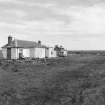
Lybster Station, Platform Building
Exterior view of platform side, looking NE |
1974 |
Item Level |
|
 |
On-line Digital Images |
SC 435430 |
Papers of Professor John R Hume, economic and industrial historian, Glasgow, Scotland |
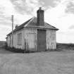
View of Lybster Station looking E.
The station was closed for regular passenger traffic in 1944. The station building now serves as the clubhouse for the Lybster golf course. |
1974 |
Item Level |
|
 |
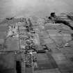
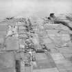
On-line Digital Images |
SC 503689 |
|
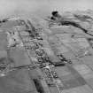
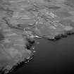
Lybster, oblique aerial view, taken from the NNE, showing Lybster village and harbour. |
|
Item Level |
|
 |
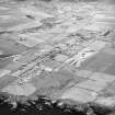
On-line Digital Images |
SC 873670 |
RCAHMS Aerial Photography |
Oblique aerial view of Lybster, taken from the SW, showing village and harbour. |
13/6/1995 |
Item Level |
|
 |
On-line Digital Images |
SC 873675 |
RCAHMS Aerial Photography |
Oblique aerial view of Lybster, taken from the SW, showing village and harbour. |
13/6/1995 |
Item Level |
|
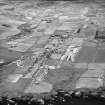 |
On-line Digital Images |
SC 1675378 |
RCAHMS Aerial Photography |
Lybster, oblique aerial view, taken from the SE, showing Lybster village in the centre of the photograph, and the remains of two buildings in the bottom right-hand corner. |
13/6/1995 |
Item Level |
|
 |
On-line Digital Images |
SC 1675379 |
RCAHMS Aerial Photography |
Lybster, oblique aerial view, taken from the SE, showing Lybster village in the centre of the photograph, and the remains of two buildings in the bottom right-hand corner. |
13/6/1995 |
Item Level |
|
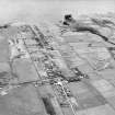 |
On-line Digital Images |
SC 1675380 |
RCAHMS Aerial Photography |
Lybster, oblique aerial view, taken from the NNE, showing Lybster village and harbour. |
13/6/1995 |
Item Level |
|
 |
On-line Digital Images |
SC 1675381 |
RCAHMS Aerial Photography |
Lybster, oblique aerial view, taken from the NNE, showing Lybster village and harbour. |
13/6/1995 |
Item Level |
|
 |
On-line Digital Images |
SC 2353449 |
Records of the Ordnance Survey, Southampton, Hampshire, England |
Wick To Lybster Light Railway, Lybster Station, ND23NW 29, Ordnance Survey index card, Recto |
c. 1958 |
Item Level |
|


