
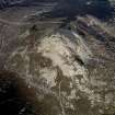
Mither Tap Of Bennachie


Fort (Prehistoric)
Site Name Mither Tap Of Bennachie
Classification Fort (Prehistoric)
Alternative Name(s) Maiden Causeway; Mither Tap O' Bennachie
Canmore ID 85507
Site Number NJ62SE 1
NGR NJ 6825 2240
Datum OSGB36 - NGR
Permalink http://canmore.org.uk/site/85507


First 100 images shown. See the Collections panel (below) for a link to all digital images.
- Council Aberdeenshire
- Parish Oyne
- Former Region Grampian
- Former District Gordon
- Former County Aberdeenshire
NJ62SE 1 6825 2240
(NJ 6825 2240) Fort (NR)
Maiden Causeway (NAT)
OS 6" map, (1959)
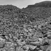
A fort occupying the Mither Tap o' Bennachie, a granite and felspar tor which commands an extensive view eastwards from the most easterly of the several summits of the Bennachie conmontation at a height of 1698ft (518m) OD.
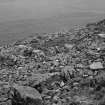
The ruined walls of the fort mingle with the fragmented tor to produce enormous masses of tumbled blocks and boulders among which it is not easy to make out the plan of the fort.
The outermost wall about 15' thick, runs round the bottom of the tor nearly 100' below the summit; several stretches of its faces can be distinguished and there are suggestions of a parapet in one place. A second wall encircles the interior of the enclosure thus formed about half-way up towards the summit. Traces of circular stone foundations, probably though not necessarily of later date than the fort, lie between the walls and above the inner wall.
Simpson (1943) notes an 'hour-glass' entrance on the north and the former existence of a carefully built well which contained water until about the beginning of the 20th century when it was filled in.
W D Simpson 1943; C Maclagan nd; R W Feachem 1963.
'The Maiden Causeway' is a paved road leading from the fort, which is said to have run to Maiden Castle (NJ62SE 2). 'One branch, seemingly the principal one, leaves the camp on the west side; another not quite so perfect leaves it on the east, and both meet at the foot of a small rock called the Nether Maiden (NJ 682 224). From this the road can be traced for a short distance when it disappears, or nearly so. It can again be distinctly traced where it crossed the head of Rushmill Burn (NJ 680 229) and from thence is very perfect until it joins the present road up the hill. From where it leaves this road at the top of Stay Knowe (NJ 685 235), and at this place is the most perfect portion, it is traceable to the woods of Pittodrie.
Although supposed to lead to the Maiden Castle it cannot be traced through the woods' (ONB 1867).
There is a theory that the Maiden Causeway was built to remove the stone from the fort (McConnochie 1890).
Name Book 1867; A I McConnochie 1890.
A fort consisting of thick inner and outer walls, with a hornwork covering the entrance in the NE. Both walls have collapsed and are now no more than wide bands of scree in which a facing stone can occasionally be seen.
The outer wall averages 7.0m in thickness and has its inner and outer faces preserved in places to a maximum height of 1.7m. Parts of a wall walk on the wall head, (averaging 2.0m wide and 0.8m high) are also preserved on both sides of the main entrance. Towards its S end a partially collapsed gallery (0.8m wide and 1.8m deep where best preserved) is visible on the inner side of the wall with at least two places where the gallery expands, suggesting a cell or an entrance. Close to where the wall terminates on outcrop in the S, and on the line of the gallery but apparently isolated from it, is a roughly square 'cell' (1.2 x 1.2m). In the N the wall contracts to 2.7m in width at an entrance 0.8m wide, which may be an access to the hornwork. In the SW a modern path climbs up through the collapsed wall at a point where the debris is very thin, and there are suggestions of another original entrance here.
The wall of the hornwork (1.8m wide in the E) runs along the edge of a low outcrop and is in a poor state of preservation.
The main entrance passage is 16.0m long and averages 3.0m wide and appears to have been paved. At its inner end on the NE side an upright stone (1.3m high) and a jut opposite on the S side have apparently been door jambs. The sides of the passage curve into the interior beyond the line of the inner wall face for about 3.0m, possibly helping to buttress an access to the wall head on either side of the entrance.
The inner wall, on a steeper slope, has almost completely collapsed. Only at one point in the S can the outer face be seen and here the wall seems to have been about 7.0m thick. Immediately SW of this point are traces of a built entrance 0.8m wide which has utilised a rock fault in its construction.
Inside this inner wall is a level shelf, backed by another band of scree which has uncertainly been another wall. On the shelf there appears to be a roughly rectangular building measuring about 8.0m NE-SW by 6.0m within a wall reduced to a band of rubble 2.0m wide. In the NE are fragments of its inner face and in the NE corner is a roughly oval cell 4.0m NW-SE by 2.0m.
To the NW of the main entrance, close to the inner wall face, are two level platforms (measuring 5.5m circular and 7.5 NW-SE by 5.5m) which could have been hut stances. To the S of the main entrance and against the inner wall face are several hollowed patches of debris, probably the result of recent attempts to locate the course of the gallery.
Surveyed at 1/10 000.
Englargement at 1/2500.
Maiden Causeway is a track averaging 3.5m wide reduced in places to a hollow way. Only for a length of about 60.0m immediately outside the entrance to the fort is there any definite sign of paving. Elsewhere this effect is created by the striated rock strata where the track has been weathered to bed rock. There is nothing to date it by, but several other tracks branch from it and it appears to be one of the main access roads to the Bennachie range and, as such, could be at least medieval if not an original route to the fort.
Visited by OS (ISS) 31 July 1973.
No change to previous field report.
Surveyed at 1:10 000.
Visited by OS (FM) 18 August 1977.
Baillies of Bennachie cut five trenches along the supposed line of the Causeway (just N and S of the Rushmill Burn) in Spring 1980. The two cuts N of the Burn were on the line of a track, but the possible surfaces exposed were of different relative ages. The cuts S of the burn revealed no definite evidence.
[Air photographic imagery and newspaper accounts listed].
NMRS, MS/712/36.
Air photograph: AAS/00/10/CT.
NMRS, MS/712/100.
Scheduled as 'Mither Tap, fort...'
Information from Historic Scotland, scheduling document dated 5 March 2008.
NJ 6825 2240 A watching brief was maintained from 13-15 November 2007 during the construction of a new path. The
monitoring revealed a stone block, possibly a step, near the inner entrance to the fort. This is likely to represent part of an earlier modern path.
Within the fort and also close to the entrance were noted two stone blocks running across the path tray on a NW-SE alignment. Immediately below this and to the S, with a visible width of approx 1m, was a roughly compacted spread of cobbles. This spread was confined to the W by a large stone on the slope of the tor and to the E by rubble. A small sondage was excavated to determine the nature of the deposits below the cobbles. This revealed a dark, gravelly silt deposit that lay directly on top of bedrock. The function of these features is uncertain, although they are tentatively interpreted as a structure and surface; perhaps vestiges of one of the roundhouses located in this area by Maclagan in 1876. Two fragments of oak (Quercus) charcoal were retrieved from a sample taken from the deposit beneath the cobbles and submitted for radiocarbon dating. They provided calibrated dates AD 640-780 and AD 340-540 at a two-sigma level of confidence. The dates support the interpretation of the fort as being early historic in origin.
Approximately 14m to the N of these features was noted a loose concentration of what appear to be heat-affected stones. The stones were not vitrified and did not appear to be part of a structure. It is considered that they represent loose rubble and tumble at the base of the slope.
Archive to be deposited with RCAHMS. Report deposited with Aberdeenshire SMR and RCAHMS
Funder: The Forestry Commission Scotland.
Dan Atkinson, 2007.
Antiquarian Observation (1850 - 1901)
Drawings by Christian MacLagan of sites across Scotland in the Society of Antiquaries of Scotland Collection at HES.
Publication Account (1986)
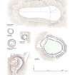
The most easterly of the granite tors of the evocative Bennachie massif rises to the not inconsiderable height of 518m and is flanked by an unusual stonewalled fort. About 30m below the summit the main wall, c 7m wide and up to 1.7m high, of drystone construction, can be seen. A triangular annexe lies to the west of the entrance which itself is in the north-eastern arc of the wall. The elaborate entrance runs for 16m, extending into the fort. Traces of a parapet on the wallhead can be seen on either side of the entrance passage. (Visitors are requested not to climb on the walls.) An inner wall is represented by tumble and scree around the main tor. A well or cistern is against the south arc of the outer wall, while a second entrance may have been on the south-western circuit. Excavations in the 1870s revealed up to 10 hut foundations, several of which must have represented secondary occupation as they had been built on top of stones fallen from the ruined wall.
The area to the north of Bennachie has been claimed as the site of the battle of Mons Graupius in AD 84 on the basis of a large temporary Roman camp found at Durno (NJ 698271). However, the construction of the Mither Tap fort around the rocky outcrops of the summit has more in common with early historic practices than with iron-age traditions.
Information from ‘Exploring Scotland’s Heritage: Grampian’, (1986).
Field Visit (21 May 1996)
The fort that crowns the Mither Tap o’ Bennachie is defended by several massive stone walls now largely reduced to vast screes of rubble. The innermost wall defends the boss of bare granite that forms the distinctive summit of the hill and survives only as two steep screes of rubble on the NE and SE, the latter with a stretch of outer facing stones on a ledge immediately above. Below this on the S and E, there is a second wall and this too is represented by a long scree of rubble that falls more or less to the foot of the boss. Together these two walls enclose little measurable space for occupation and may have formed an inner citadel.
Encircling the boss beyond these, there are the remains of an impressive stone wall some 8m thick much of which has collapsed downslope forming a massive skirt of rubble around the hill. At several places in the rubble, substantial stretches of outer face can still be seen, the most continuous extending south from the stone-lined entrance on the ENE. This entrance passage climbs into the interior and at least some of the stones facing the inner end of the passage may be original, turning either side to form a kerbed plinth at the foot of the inner face of the wall. Here, the inner face of the wall has been raised in a series of steps or tiers, the lower standing nine courses high and the upper five course high, and presumably culminated in a parapet at least one tier above the level of the surviving masonry. The sheer scale of this wall indicates that at some stage it was the principal line of defence, spanning the spine of rock outcrop on the SW and abutting either side of the vertical face of the boss on the N. This wall enclosed an oval area measuring about 120m from NNE to SSW by 70m transversely, though again little of the space provided for accommodation.
This massive wall evidently replaced an earlier defence lying immediately inside its circuit though its precise course remains uncertain. Where best preserved on the S, it survives as an artificial terrace faced with large blocks standing to a height 1.2m and retaining a possible entrance on the SSE. To the NE, this terrace tails off into a low scarp before petering out, but to the W it appears to turn, as if to cut over the spine of outcrop descending from the summit, disappearing in a scatter of large boulders strewn across the slope. This corresponds to the position of a slight break in slope to the W of the spine, but on this side of the fort there is also a heather-grown stony bank behind the S end of the outer wall; it too has traces of an entrance matched by a gap in the outer wall. Internally, this wall enclosed an oval area measuring about 95m from NE to SW by 70m transversely.
Without excavation, the sequence and arrangement of these defences cannot be fully understood.
Visited by RCAHMS (ARG, KM) 21 May 1996.
Publication Account (1996)
The most easterly of the granite tors of the evocative Bennachie massif rises to the not inconsiderable height of 518m and is flanked by an unusual stone-walled fort. About 30m below the summit the main wall, c 7m wide and up to 1.7m high, of drystone construction, can be seen. A triangular annexe lies to the west of the entrance which itself is in the north-eastern arc of the wall. The elaborate entrance runs for 16 m, extending into the fort. Traces of a parapet on the wallhead can be seen on either side of the entrance passage. (Visitors are requested not to climb on the walls.) An inner wall is represented by tumble and scree around the main tor. A well or cistern is against the south arc of the outer wall, while a second entrance may have been on the south-western circuit. Excavations in the 1870s revealed up to 10 hut foundations, several of which must have represented secondary occupation as they had been built on top of stones fallen from the ruined wall.
The area to the north of Bennachie has been claimed as the site of the battle of Mons Graupius in AD 84 on the basis of a large temporary Roman camp found at Durno (NJ 698271 ). However, the construction of the Mither Tap fort around the rocky outcrops of the summit has more in common with early historic practices than with iron-age traditions.
Information from ‘Exploring Scotland’s Heritage: Aberdeen and North-East Scotland’, (1996).
Watching Brief (13 November 2006 - 15 November 2006)
NJ 6825 2240 A watching brief was maintained from 13-15 November 2006 during the construction of a new path. The monitoring revealed a stone block, possibly a step, near the inner entrance to the fort. This is likely to represent part of an earlier modern path.
Within the fort and also close to the entrance were noted two stone blocks running across the path tray on a NW-SE alignment. Immediately below this and to the S, with a visible width of approx 1m, was a roughly compacted spread of cobbles. This spread was confined to the W by a large stone on the slope of the tor and to the E by rubble. A small sondage was excavated to determine the nature of the deposits below the cobbles. This revealed a dark, gravelly silt deposit that lay directly on top of bedrock. The function of these features is uncertain, although they are tentatively interpreted as a structure and surface; perhaps vestiges of one of the roundhouses located in this area by Maclagan in 1876. Two fragments of oak (Quercus) charcoal were retrieved from a sample taken from the deposit beneath the cobbles and submitted for radiocarbon dating. They provided calibrated dates AD 640-780 and AD 340-540 at a two-sigma level of confidence. The dates support the interpretation of the fort as being early historic in origin.
Approximately 14m to the N of these features was noted a loose concentration of what appear to be heat-affected stones. The stones were not vitrified and did not appear to be part of a structure. It is considered that they represent loose rubble and tumble at the base of the slope.
Archive to be deposited with RCAHMS. Report deposited with Aberdeenshire SMR and RCAHMS
Funder: The Forestry Commission Scotland.
Dan Atkinson, 2006.
Publication Account (2009)
The website text produced for Bennachie webpages on the Forest Heritage Scotland website (www.forestheritagescotland.com).
Introduction: The hillside of Bennachie
This moorland was not meant to be lived on. It was a ]'commonty'; common land shared by the neighbouring landlords. People were allowed to use this land for free to graze sheep or cattle. They could also draw on its natural resources of wood, peat, stone and heather. It was not land for growing crops.
In 1801, while people were being forced off land elsewhere, one man decided to live on the rent-free slopes of Bennachie. Other families soon joined him and a farming community grew. In 1859, however, the landlords divided the ownership of the commonty and began to charge rent. Some families could not afford to stay, others were evicted, but a few remained and continued to farm.
Our "Colony" walk will lead you around the remains of the houses that belonged to this short-lived community.
People Story: Descended from the first and himself the last
The people of Bennachie were locally known as "squatters" because they did not pay rent. Yet one nearby resident, James Allan, tells us that locals saw them as respectable people who worked hard.
The Esson family is one of the many families that we know lived at Bennachie. William Esson was among the earliest settlers to the colony. In 1829 he built the farmstead known as Boghead of Tullos with his wife, Jean Petrie, and son, John. This house was the last to be abandoned when his grandson, George, died in 1939.
George Esson, like many of his family, was a stone mason and noted dry stone dyker. He was educated and had lived a short time in America. He returned to Scotland, however, and farmed his father's croft with his wife Mary Ann Knight. You can search for the remains of their home, still visible, at the eastern end of the colony.
Their house is not on our trail but many of the remains of other squatters' houses are. We know that the Findlater family lived in a cottage called Burnside. Their cottage may have been one close to the stream. See if you can spot the last remains of their squatter home as you walk along.
Evidence Story: Scottish Episcopal Palaces Project
In 1996, funded by the Bennachie Centre and the Bailies of Bennachie, the Scottish Episcopal Palaces Project excavated one of the houses at Bennachie.
In 1995, project focused on the area by excavating the pre-Reformation summer palace of the bishops of Fetternear.
These buildings were later converted first into a tower house and then into a mansion for the owners of the Fetternear estate.
The project also wanted to investigate the places where the ordinary families lived on the estate.
The excavations of the Bennachie house revealed a small, rectangular building, only 8 metres long by 5 metres wide. The walls only survived to a low height. In the west end of the building, they found a fireplace with the remains of the last peat fire burnt in the house remaining.
Finds included 19th century pottery, two leather shoes and a metal belt buckle. They also found the bowl of an old clay pipe, used for smoking tobacco.
Carefully placed trenches on the outside of the building shows that this house had a small enclosure, as well as its own garden. In addition, two fields were associated with the house. The people who lived there would have grown their own vegetables and crops as well as keep some livestock.
Mixed within the interior rubble they discovered a small amount of burnt material. It is possible that the roof was burnt and the walls pushed in to force the house to collapse.
Note (20 April 2015 - 18 October 2016)
The dominant landmark in the centre of Aberdeenshire, The Mither Tap o' Bennachie, is crowned by a spectacular fortification with massive walls. The summit of the hill is an inhospitable boss of bare rock which was probably once enclosed by a wall, though the only trace of it remaining is a line of outer facing-stones on a ledge above a scree of rubble on the SE, and another scree below the crag on the NE. Below this wall on the S and E there has been a second wall, though again this is largely reduced to a scree dropping almost to the foot of the slope, while encircling the foot of the boss is a massive wall some 8m in thickness, which apparently rose internally in at least two built steps from a kerbed plinth that can be detected at its foot to the N of the entrance on the ENE. Where best preserved, the lower and upper steps of the inner face are nine and five course high respectively, presumably culminating in a parapet at least one tier above this level, and long runs of the outer face can also be traced at several places in the rubble. The sheer scale of this wall suggests that it has been at some stage the principal line of defence, swinging round the NE and SE flanks of the boss from its vertical face on the N to the terminal of the spine of outcrop dropping down from the boss on the SSW; on the W the wall likewise extends from the cliff-face to the terminal of this spine, and though it must once have spanned the outcrops to complete the southern sector of the circuit, no trace of any rubble now survives here. This outer defence evidently replaced an earlier wall lying immediately inside its line, on the S forming a terrace faced with large blocks to a height of 1.2m in height and possibly retaining the remains of an earlier entrance on the SSE. The precise course of this earlier circuit is uncertain, for while it may have cut back W across the spine of rocks, there are also traces of an earlier wall behind the S end of the bank of rubble forming the W sector of the enclosure; it too has traces of an entrance immediately opposite the gap in the rubble here. The interior of the citadel-like enclosures taking in the summit of the boss are unmeasurable, though the inner cannot have exceeded (0.06ha). In its second phase the outer wall enclosed an oval area measuring about 120m from NNE to SSW by 70m transversely (0.67ha), though relatively little of it could have been occupied. Two later pens are visible immediately behind the lower of the two walls on the boss, but Christian Maclagan's account drawn up in the late 19th century is probably not a particularly reliable guide to the former presence of other structures in the interior. The fort with its viewpoint on the summit has been a major attraction for walkers and tourists, which has led to significant later disturbance, including the construction of wall-faces to revet the tumbled rubble to either side of the track approaching the entrance on the ENE before 1867; the date of a wall extending round an outcrop on the N side of this track is unknown. Remedial works along the pathway within the entrance recovered stratified charcoal samples that have been date to the early medieval period, though their precise context remains obscure (Atkinson 2006).
Information from An Atlas of Hillforts of Great Britain and Ireland – 18 October 2016. Atlas of Hillforts SC2961
Lidar Survey (March 2015)
NJ 682 224 (Mither Tap – NJ62SE 1) and NJ 484 292 (Tap o’ Noth – NJ42NE 1) A partnership between Forestry Commission Scotland, The University of Aberdeen and Aberdeenshire Council enabled the high resolution Aerial Laser Scan (or LiDAR) survey of the important Pictish forts of the Mither Tap and Tap o’ Noth in March 2015. The resulting terrain models will enable the detailed study and visualisation of the forts in their wider landscape. Bluesky International provided a series of 0.5m DSM (Digital Surface Model) and DTM (Digital Terrain Model) tiles. Forest Research then created a series of single files: ‘East’ (the Mither Tap and environs) and ‘West’ (Tap o’ Noth and environs) both as 0.5m models each covering c10 km2 (and equating to 4 points per square metre); and, because the raw point cloud data was so dense (often 30+ points per metre) more detailed DSMs for the forts themselves (at 0.2m
or 25 points per square metre).
Archive: National Record of the Historic Environment (NRHE)
Report: Forestry Commission Scotland, University of Aberdeen and Aberdeenshire HER
Funder: Aberdeenshire Council Archaeology Service, University of Aberdeen and Forestry Commission Scotland
Bruce Mann, Gordon Noble and Matt Ritchie – Aberdeenshire Council Archaeology Service, University of Aberdeen and Forestry Commission Scotland
(Source: DES, Volume 16)
Excavation (3 June 2019 - 17 June 2019)
NJ 6825 2240 Excavation occurred in June 2019 with 7 trenches being excavated on the Mither Tap of Bennachie (Canmore ID: 85507).
Trench 1 measured 5.5 x 4m and excavated the outer rampart and what turned out to be an inner building platform. Four courses of the wall face survived on the north side of the trench and up to seven in the centre. The rampart was built up on huge granite slabs, which were built up on top of mounds of voided rubble. A sondage was excavated, however this work was stopped due to safety reasons.
The inner building was built approximately 1.5m above the rampart base and was revetted by large granite slabs up to 1 x 0.05 x 0.4m thick. Inside the building a midden deposit with large quantities of animal bone including cattle, sheep, and fish bone was found. Multiple animal jaws and large bone fragments were identified.
Trench 2 targeted the well that was referenced by Maclagan’s 1881 excavation. Removing the topsoil revealed a rectangular stone lined structure. Further excavation revealed a number of large stones that had been put into the well to block it off. Once the stones were removed from the well a silty deposit was present with modern plastic, glass, and ceramics. The modern material continued to the base of the well. A clay lining was found which may have been part of the original sealing of the well. Steps led to the well, which seem to be contemporary with it and were keyed into the stonework of the rampart.
On the SE side of the fort, Trench 3 was opened over what has previously been interpreted as an outer bank. Closer inspection suggests it may actually be the wall of a sub-rectangular building that has been placed just inside the bank. A 2 x 2m area was excavated with topsoil and a layer of overburden sitting atop an extensive occupation deposit. Fragments of iron, an intact crucible, slag, and a handmade pottery shed were found in the basal levels of the deposits. The wall face still had seven courses surviving. Larger trenches will be needed to confirm that the stone facing is part of a structure rather than an enclosing element to the hillfort.
Trench 4 investigated a possible structure within the upper citadel. The trench measured 3 x 3m with a 3 x 1m sondage that hit a maximum depth of 1.3m. Frequent animal bone, teeth, and charcoal were recovered from a series of clayey silt layers that extended towards the bedrock. Finds in this area included pottery and a gaming piece.
Trench 5 was a 2 x 2m trench opened on the southern side of the central tor. The excavation revealed a thin layer of topsoil over a greyish brown silty-sand. Modern glass and charcoal flecks were present in the layer, along with a small fragment of corroded metal. Underneath was a blackish-brown clayey silt that went across the entire trench. A sondage of 2 x 0.5m went through the layer showing it extended to around 0.18m in depth. This layer had large pieces of charcoal with concentrated pockets of orange, heat affected soil. This layer sat directly on bedrock.
Trench 6, a 0.5 x 0.5m test pit was excavated on the northern side of the interior of Mither Tap to assess erosion damage caused by visitors to the site. A layer of 0.1m overburden sat atop a thick layer of mid brown clayey silt. A more extensive occupation layer of brownish black clayey-silt with moderate charcoal and stones was underneath this. The trench was not bottomed; however, a number of flat stones formed a level surface suggesting a possible path of uncertain date to the summit.
Trench 7 was positioned outside the fort on the northern side and measured approximately 2 x 1.5m. It was opened to investigate a line of boulders and large stones that stood up to three courses high. Abutting the boulders was a deep peaty topsoil laid over a dark greyish brown clayey sand with frequent amounts of charcoal, which in turn sat atop bedrock.
Archive: University of Aberdeen
Funder: University of Aberdeen
Gordon Noble, James O’Driscoll, Edouard Masson-MacLean, Cathy MacIver and Zack Hinckley – University of Aberdeen
(Source: DES Vol 20)
OASIS ID: jamesodr1-407727
Excavation (5 June 2023 - 16 June 2023)
NJ 68250 22400 Two trenches were opened at Dumyat fort as part of evaluative excavations. This revealed the heavily truncated remains of a sub-rectangular building and adjacent midden area. The building had unfortunately been dug over by antiquarian excavations in the 19th century. Parts of the midden were intact and contained abundant but highly degraded animal bone. A targeted trench in an elevated area of the lower citadel on the western side of the fort and revealed in situ remains that included part of a revetment wall and areas of metalworking debris including abundant crucible sherds and a small number of clay moulds.
Information from J. O'Driscoll and G. Noble – University of Aberdeen, 2013.
OASIS ID: universi17-518588

