
Meikle Tombane


Lade (Post Medieval), Township (Post Medieval), Watermill (Post Medieval)
Site Name Meikle Tombane
Classification Lade (Post Medieval), Township (Post Medieval), Watermill (Post Medieval)
Canmore ID 85278
Site Number NN94SW 11
NGR NN 9471 4022
Datum OSGB36 - NGR
Permalink http://canmore.org.uk/site/85278


- Council Perth And Kinross
- Parish Little Dunkeld
- Former Region Tayside
- Former District Perth And Kinross
- Former County Perthshire
Field Visit (7 December 1993)
NN94SW 11 947 402
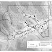
The faced-rubble footings of two buildings (Braan93 337, 338) and fragments of others have been incorporated in a garden and shelter belt associated with two roofed buildings at Meikle Tombane. Both the ruinous buildings are shown as roofed on the 1st edition of the OS 6-inch map (Perthshire 1867, sheet lxi) but had gone out of use by the date of the 2nd edition map (Perthshire 1900, sheet lxi).
The mill (Braan93 339) is levelled into the base of the steeply-incised valley side to the NW of the buildings. It measures 15m from WNW to ESE by 5.3m transversely within coursed-rubble footings 0.8m in thickness and up to 1.8m in height. The wheel-pit, probably housing an over-shot wheel, is at the WNW end of the building and measures 1.45m across. A lade, which runs in from the NW, has been dug into the NE side of the valley. The 1st edition map shows the lade being fed from two sluices on the burn and also taking in an unnamed burn flowing in from the N. The mill is depicted as roofed on the 1st edition map, but is not annotated as such, and had fallen out of use by the 2nd edition.
(Braan93 337-339)
Visited by RCAHMS (DCC) 7 December 1993.
Note (31 October 1997)
The township, comprising fourteen roofed, three of which are long buildings, two unroofed buildings and one unroofed structure is depicted on the 1st edition of the OS 6-inch map (Perthshire 1867, sheet lxi). Two roofed and three unroofed buildings are shown on the current edition of the OS 1:10000 map (1991).
Information from RCAHMS (AKK) 31 October 1997.
Management (29 October 2003)
Scheduled as Meikle Tombane, mill of post-medieval date, visible as upstanding remains (area includes well preserved section of the lade). Information from Historic Scotland, scheduling document dated 29 October 2003.

