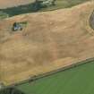
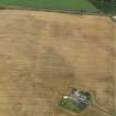
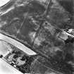
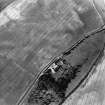
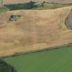
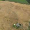
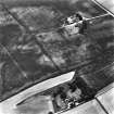
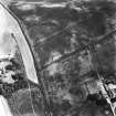
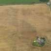
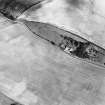
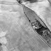
Accessibility

Font Size

100% 150% 200%

Background Colour

Default Contrast
Close Reset

Laigh Of Rossie

Rig And Furrow (Medieval) - (Post Medieval), Settlement (Period Unassigned)

Site Name Laigh Of Rossie

Classification Rig And Furrow (Medieval) - (Post Medieval), Settlement (Period Unassigned)

Canmore ID 84920

Site Number NN91NE 48

NGR NN 98687 15206

Datum OSGB36 - NGR

Permalink http://canmore.org.uk/site/84920

Ordnance Survey licence number AC0000807262. All rights reserved.
Canmore Disclaimer. © Bluesky International Limited 2025. Public Sector Viewing Terms

Toggle Aerial | View on large map

Digital Images

Oblique aerial view centred on the cropmarks of the pit defined enclosure, ring ditch and rig at Laigh of Rossie, taken from the SSE.
Oblique aerial view centred on the cropmarks of the pit defined enclosure, ring ditch and rig at Laigh of Rossie, taken from the SSE.Oblique aerial view centred on the cropmarks of the pit defined enclosure, ring ditch and rig at Laigh of Rossie, taken from the NW.Oblique aerial view.Oblique aerial view of Laigh of Rossie centred on cropmarks with settlement adjacent, taken from the S.Oblique aerial view centred on the cropmarks of the pit defined enclosure, ring ditch and rig at Laigh of Rossie, taken from the SE.Oblique aerial view centred on the cropmarks of the pit defined enclosure, ring ditch and rig at Laigh of Rossie, taken from the WNW.Oblique aerial view.Oblique aerial view.Oblique aerial view centred on the cropmarks of the pit defined enclosure, ring ditch and rig at Laigh of Rossie, taken from the NNW.Oblique aerial view of Laigh of Rossie centred on cropmarks with settlement adjacent, taken from the WNW.Oblique aerial view of Laigh of Rossie centred on cropmarks with settlement adjacent, taken from the W.

Administrative Areas

  • Council Perth And Kinross
  • Parish Auchterarder
  • Former Region Tayside
  • Former District Perth And Kinross
  • Former County Perthshire

Activities

Aerial Photographic Transcription (19 October 2017)

An interpretative transcription, or mapping, of information on oblique aerial photographs was produced on 19 October 2017.

References

MyCanmore Image Contributions


Contribute an Image

MyCanmore Text Contributions