|
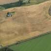
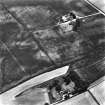
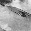
Photographs and Off-line Digital Images |
B 79181 |
RCAHMS Aerial Photography |
Oblique aerial view. |
1992 |
Item Level |
|
|
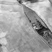
Photographs and Off-line Digital Images |
B 79182 |
RCAHMS Aerial Photography |
Oblique aerial view. |
1992 |
Item Level |
|
|
Photographs and Off-line Digital Images |
B 79183 |
RCAHMS Aerial Photography |
Oblique aerial view. |
1992 |
Item Level |
|
|
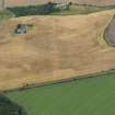
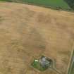
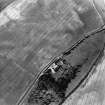
Photographs and Off-line Digital Images |
D 57083 |
RCAHMS Aerial Photography |
Oblique aerial view of Laigh of Rossie centred on cropmarks with settlement adjacent, taken from the WNW. |
22/7/1999 |
Item Level |
|
|
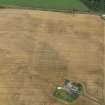
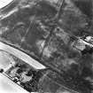
Photographs and Off-line Digital Images |
D 57084 |
RCAHMS Aerial Photography |
Oblique aerial view of Laigh of Rossie centred on cropmarks with settlement adjacent, taken from the W. |
22/7/1999 |
Item Level |
|
|
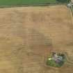
Photographs and Off-line Digital Images |
D 57085 |
RCAHMS Aerial Photography |
Oblique aerial view of Laigh of Rossie centred on cropmarks with settlement adjacent, taken from the S. |
22/7/1999 |
Item Level |
|
 |
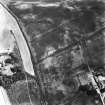
On-line Digital Images |
DP 052998 |
RCAHMS Aerial Photography Digital |
Oblique aerial view centred on the cropmarks of the pit defined enclosure, ring ditch and rig at Laigh of Rossie, taken from the SSE. |
4/8/2008 |
Item Level |
|
 |
On-line Digital Images |
DP 052999 |
RCAHMS Aerial Photography Digital |
Oblique aerial view centred on the cropmarks of the pit defined enclosure, ring ditch and rig at Laigh of Rossie, taken from the SE. |
4/8/2008 |
Item Level |
|
 |
On-line Digital Images |
DP 053003 |
RCAHMS Aerial Photography Digital |
Oblique aerial view centred on the cropmarks of the pit defined enclosure, ring ditch and rig at Laigh of Rossie, taken from the NNW. |
4/8/2008 |
Item Level |
|
 |
On-line Digital Images |
DP 053004 |
RCAHMS Aerial Photography Digital |
Oblique aerial view centred on the cropmarks of the pit defined enclosure, ring ditch and rig at Laigh of Rossie, taken from the NW. |
4/8/2008 |
Item Level |
|
 |
On-line Digital Images |
DP 053005 |
RCAHMS Aerial Photography Digital |
Oblique aerial view centred on the cropmarks of the pit defined enclosure, ring ditch and rig at Laigh of Rossie, taken from the WNW. |
4/8/2008 |
Item Level |
|
 |
On-line Digital Images |
SC 1703335 |
RCAHMS Aerial Photography |
Oblique aerial view. |
1992 |
Item Level |
|
 |
On-line Digital Images |
SC 1703336 |
RCAHMS Aerial Photography |
Oblique aerial view. |
1992 |
Item Level |
|
 |
On-line Digital Images |
SC 1703337 |
RCAHMS Aerial Photography |
Oblique aerial view. |
1992 |
Item Level |
|
 |
On-line Digital Images |
SC 1703406 |
RCAHMS Aerial Photography |
Oblique aerial view of Laigh of Rossie centred on cropmarks with settlement adjacent, taken from the WNW. |
22/7/1999 |
Item Level |
|
 |
On-line Digital Images |
SC 1703407 |
RCAHMS Aerial Photography |
Oblique aerial view of Laigh of Rossie centred on cropmarks with settlement adjacent, taken from the W. |
22/7/1999 |
Item Level |
|
 |
On-line Digital Images |
SC 1703408 |
RCAHMS Aerial Photography |
Oblique aerial view of Laigh of Rossie centred on cropmarks with settlement adjacent, taken from the S. |
22/7/1999 |
Item Level |
|
|
On-line Digital Images |
AT 003351 |
Historic Environment Scotland |
Imagery and mapping Files for Aerial Photo Transcription |
19/10/2017 |
Item Level |
|


