Accessibility

Font Size

100% 150% 200%

Background Colour

Default Contrast
Close Reset

Ballinreigh

Building (Post Medieval), Hut (Post Medieval)

Site Name Ballinreigh

Classification Building (Post Medieval), Hut (Post Medieval)

Canmore ID 84877

Site Number NN93NW 13.11

NGR NN 9055 3789

Datum OSGB36 - NGR

Permalink http://canmore.org.uk/site/84877

Ordnance Survey licence number AC0000807262. All rights reserved.
Canmore Disclaimer. © Bluesky International Limited 2025. Public Sector Viewing Terms

Toggle Aerial | View on large map

Digital Images

Plan of archaeological landscape at Glen Fender
Plan of archaeological landscape at Glen FenderGlen Fender, oblique aerial view, taken from the WNW, centred on the remains of a township. Footings of two buildings and a hut, and a field-system, are visible along the bottom edge of the photograph. Remains of a farmstead, buildings and township are visible in the top half.Glen Fender, oblique aerial view, taken from the WNW, centred on the footings of a building and hut. Another building and parts of a field-system are visible in the centre left of the photograph. Remains of a township and farmstead are visible in the top half.Distribution map of medieval and later settlement. Generated from RCAHMS computer file DC37330ai.Glen Fender, oblique aerial view, taken from the WNW, centred on the remains of a township. Footings of two buildings are visible in the bottom half of the photograph, and of a farmstead and buildings in the top centre.Oblique aerial view of the township, field boundaries and small cairns, looking W.Oblique aerial view of the township, field boundaries and small cairns, looking NE.Oblique aerial view of the township, field boundaries and small cairns, looking SE.Oblique aerial view of the township, field boundaries and small cairns, looking NE.

Administrative Areas

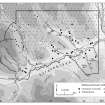
  • Council Perth And Kinross
  • Parish Little Dunkeld
  • Former Region Tayside
  • Former District Perth And Kinross
  • Former County Perthshire

Activities

Field Visit (8 December 1993)

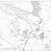
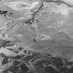
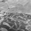
NN93NW 13.11 9055 3789

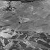
This two-phase building has been overlain by a hut. In its earlier phase, the building measured 18.6m from E to W by 3.4m transversely within a stony bank spread to 1.2m in thickness and 0.3m in height. In the second phase, the E end was demolished and the W end appears to have been rebuilt. Finally the building has been overlain by a hut which measures 4.7m by 3.4m internally.

(Braan93 444)

Visited by RCAHMS (DCC) 8 December 1993

References

MyCanmore Image Contributions


Contribute an Image

MyCanmore Text Contributions