
Ballinreigh


Pitcarmick Building (Early Medieval)(Possible)
Site Name Ballinreigh
Classification Pitcarmick Building (Early Medieval)(Possible)
Canmore ID 84876
Site Number NN93NW 13.10
NGR NN 9056 3776
Datum OSGB36 - NGR
Permalink http://canmore.org.uk/site/84876


- Council Perth And Kinross
- Parish Little Dunkeld
- Former Region Tayside
- Former District Perth And Kinross
- Former County Perthshire
Field Visit (8 December 1993)
NN93NW 13.10 9056 3776
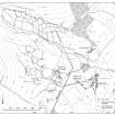
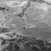
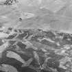
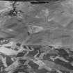
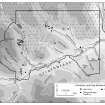
What may be a Pitcarmick-type building is situated on a small heather-covered terrace and lies amongst a scatter of small cairns and field-banks (NN93NW 13.07). The building is sub-rectangular, with rounded ends, and measures 21.5m from NE to SW by 5m transversely within a stone-faced earthen bank 1.5m in thickness and 0.4m in height. The entrance is on the SE side, and there is a slight break of slope midway down the slightly dished interior. There is a drain along the NW side, which has a slight kink in it towards the SW end of the building.
(Braan93 465)
Visited by RCAHMS (DCC) 8 December 1993
Field Visit (8 December 1993)
NN93NW 13.10 9056 3776
What may be a Pitcarmick-type building is situated on a small heather-covered terrace and lies amongst a scatter of small cairns and field-banks (NN93NW 13.07). The building is sub-rectangular, with rounded ends, and measures 21.5m from NE to SW by 5m transversely within a stone-faced earthen bank 1.5m in thickness and 0.4m in height. The entrance is on the SE side, and there is a slight break of slope midway down the slightly dished interior. There is a drain along the NW side, which has a slight kink in it towards the SW end of the building.
(Braan93 465)
Visited by RCAHMS (DCC) 8 December 1993

