
Ballinreigh


Hut Circle(S) (Prehistoric)
Site Name Ballinreigh
Classification Hut Circle(S) (Prehistoric)
Canmore ID 84874
Site Number NN93NW 13.08
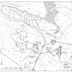
NGR NN 9061 3803
NGR Description NN 9061 3803, NN 9066 3777 and NN 9057 3769
Datum OSGB36 - NGR
Permalink http://canmore.org.uk/site/84874


- Council Perth And Kinross
- Parish Little Dunkeld
- Former Region Tayside
- Former District Perth And Kinross
- Former County Perthshire
Field Visit (8 December 1993)
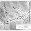
NN93NW 13.08 9061 3803, 9066 3777 and 9057 3769
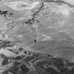
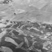
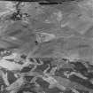
Three hut-circles (NN 9061 3803, Braan 443; NN 9066 3777, Braan 464; and NN 9057 3769, Braan 466) are situated on terraces in the unimproved heather moor to the NW of the improved fields. The two smaller hut-circles, measuring 5.9m (Braan93 443) and 6.5m (Braan93 464) in diameter within stony banks spread to 1.8m in thickness and 0.4m in height, are cut by tracks. The third hut-circle (Braan93 466) is much larger, comprising a platform 13m in diameter, around which intermittent traces of a stony bank are visible.
(Braan93 443, 464, 466)
Visited by RCAHMS (DCC) 8 December 1993

