
Pricing Change
New pricing for orders of material from this site will come into place shortly. Charges for supply of digital images, digitisation on demand, prints and licensing will be altered.
Upcoming Maintenance
Please be advised that this website will undergo scheduled maintenance on the following dates:
Thursday, 9 January: 11:00 AM - 3:00 PM
Thursday, 23 January: 11:00 AM - 3:00 PM
Thursday, 30 January: 11:00 AM - 3:00 PM
During these times, some functionality such as image purchasing may be temporarily unavailable. We apologise for any inconvenience this may cause.
Newton Of Ballinreigh


Township (Post Medieval)
Site Name Newton Of Ballinreigh
Classification Township (Post Medieval)
Canmore ID 84869
Site Number NN93NW 13.03
NGR NN 908 378
Datum OSGB36 - NGR
Permalink http://canmore.org.uk/site/84869


- Council Perth And Kinross
- Parish Little Dunkeld
- Former Region Tayside
- Former District Perth And Kinross
- Former County Perthshire
Field Visit (23 November 1993)
NN93NW 13.03 908 378
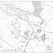
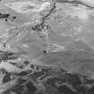
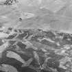
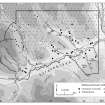
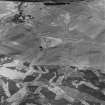
This township is situated on a broad terrace to the NW of the Coupar Angus to Amulree military road (NN93NW 8) and comprises three steadings composed of two to three buildings and an enclosure. The buildings, eight in all (Braan93 46-49, 184-187), measure between 3.9m by 2.4m (Braan93 48) and 28.3m by 4m (Braan93 184) within faced-rubble footings up to 1m in thickness and 1m in height, and contain up to five compartments. What may be cruck slots are visible in one building (NN 9083 3787, Braan93 184). A build-up of soil inside two of the enclosures (NN 9079 3785 and NN 9086 3778) suggests that they may have been garden plots, while there is a rectangular stack-stand in one of the other enclosures (NN 9086 3786). Four circular or sub-rectangular pits (NN 9085 3780, NN 9082 3782, NN 9081 3784 and NN 9083 3786) disposed across the site may have been middens. A trackway runs into the site from the military road to the E.
Three of the buildings (Braan93 47, 49, 187) are shown as roofed on the 1st edition of the OS 6-inch map (Perthshire 1867, sheet lxxi), but had been abandoned by the date of the 2nd edition map (Perthshire 1901, sheet lxxi).
(Braan93 46-49, 184-187)
Visited by RCAHMS (DCC) 23 November 1993.
Note (4 February 1998)
A township, comprising four roofed buildings, one unroofed building and three enclosures is depicted on the 1st edition of the OS 6-inch map (Perthshire 1867, sheet lxxi). Three unroofed buildings and six enclosure are shown on the current edition of the OS 1:10000 map (1982).
Information from RCAHMS (AKK) 4 February 1998.

