
Midtown Of Ballinreigh


Farmstead (Post Medieval), Pitcarmick Building (Early Medieval)(Possible)
Site Name Midtown Of Ballinreigh
Classification Farmstead (Post Medieval), Pitcarmick Building (Early Medieval)(Possible)
Canmore ID 84865
Site Number NN93NW 13.02
NGR NN 911 377
Datum OSGB36 - NGR
Permalink http://canmore.org.uk/site/84865


- Council Perth And Kinross
- Parish Little Dunkeld
- Former Region Tayside
- Former District Perth And Kinross
- Former County Perthshire
Field Visit (6 December 1993)
NN93NW 13.02 911 377
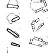
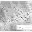
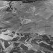
This farmstead, comprising two buildings (Braan93 188-189) and three enclosures, is situated on the N side of the track leading out of Ballinreigh (NN 93NW 13.01) towards the Coupar Angus to Amulree military road (NN93NW 8). The larger building (NN 9110 3772, Braan93 188) measures 27.5m by 3.8m within faced-rubble walls 0.6m in thickness and 1m in height. It has four compartments and the S-facing wall has been buttressed. The second building (NN 9112 3771, Braan93 189) measures 14.7m by 3m internally and has two compartments. Both buildings are shown as roofed on the 1st and 2nd editions of the OS 6-inch map (Perthshire 1867, 1900, sheet lxi).
What may be a Pitcarmick-type building (Braan93 190) is situated on a low rise to the SE of the farmstead at NN 9117 3768. It has rounded ends, slightly bowed walls and measures 17.5m from ENE to WSW by 4.9m internally within a grass-grown stony bank spread to 1.8m in thickness and 0.3m in height. The entrance is in the centre of the SSE side, beside a slight break of slope in the interior. An irregular enclosure lies on the NW side of the building.
(Braan93 188-190)
Visited by RCAHMS (DCC) 6 December 1993
Field Visit (6 December 1993)
NN93NW 13.02 911 377
This farmstead, comprising two buildings (Braan93 188-189) and three enclosures, is situated on the N side of the track leading out of Ballinreigh (NN 93NW 13.01) towards the Coupar Angus to Amulree military road (NN93NW 8). The larger building (NN 9110 3772, Braan93 188) measures 27.5m by 3.8m within faced-rubble walls 0.6m in thickness and 1m in height. It has four compartments and the S-facing wall has been buttressed. The second building (NN 9112 3771, Braan93 189) measures 14.7m by 3m internally and has two compartments. Both buildings are shown as roofed on the 1st and 2nd editions of the OS 6-inch map (Perthshire 1867, 1900, sheet lxi).
What may be a Pitcarmick-type building (Braan93 190) is situated on a low rise to the SE of the farmstead at NN 9117 3768. It has rounded ends, slightly bowed walls and measures 17.5m from ENE to WSW by 4.9m internally within a grass-grown stony bank spread to 1.8m in thickness and 0.3m in height. The entrance is in the centre of the SSE side, beside a slight break of slope in the interior. An irregular enclosure lies on the NW side of the building.
(Braan93 188-190)
Visited by RCAHMS (DCC) 6 December 1993

