
Pricing Change
New pricing for orders of material from this site will come into place shortly. Charges for supply of digital images, digitisation on demand, prints and licensing will be altered.
Glen Fender


Archaeological Landscape (Prehistoric) - (Post Medieval)
Site Name Glen Fender
Classification Archaeological Landscape (Prehistoric) - (Post Medieval)
Alternative Name(s) Ballinreigh
Canmore ID 84854
Site Number NN93NW 13
NGR NN 905 377
NGR Description Centred on NN 905 377
Datum OSGB36 - NGR
Permalink http://canmore.org.uk/site/84854


- Council Perth And Kinross
- Parish Little Dunkeld
- Former Region Tayside
- Former District Perth And Kinross
- Former County Perthshire
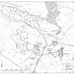
NN93NW 13.00 centred on 905 377
NN93NW 13.01 NN 912 376 Newton of Ballinreigh Township (Braan93 31-7,191-9, 321-8)
NN93NW 13.02 NN 911 377 Midtown of Ballinreigh Farmstead; Building: Pitcarmick-type (possible)
(Braan93 188-190)
NN93NW 13.03 NN 908 378 Newton of Ballinreigh Township (Braan93 46-9, 184-7)
NN93NW 13.04 NN 9112 3729 Ballinreigh Kiln (Braan93 462)
NN93NW 13.05 NN 9077 3757 Ballinreigh Stone: cross-incised (Braan93 355)
NN93NW 13.06 NN 9070 3747 Ballinreigh Building:Pitcarmick-type (possible); Small Cairns; Field-system (Braan93 463)
NN93NW 13.07 NN c.90 38 Ballinreigh Field-system; Small cairns; Rig; Tracks
NN93NW 13.08 NN c.90 38 Ballinreigh Hut-circles (Braan93 443, 464, 466)
NN93NW 13.09 NN c.90 37 Ballinreigh Huts (Braan93 431-5, 442)
NN93NW 13.10 NN 9056 3776 Ballinreigh Building (Braan93 465)
NN93NW 13.11 NN 9055 3789 Ballinreigh Building (Braan93 444)
NN93NW 13.12 NN 9024 3831 Ballinreigh Hut; Small cairns (Braan93 436)
NN93NW 13.13 NN 912 381 Innercochill Township (Braan93 25-30)
NN93NW 13.14 NN c.90 37 Glen Fender Field-system; Rig; Lade; Buildings (Braan93 399, 413-18)
NN93NW 13.15 NN 9087 3850 Glen Fender Hut-circle (Braan93 400)
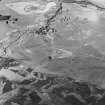
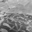
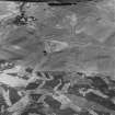
The Glenfender Burn debouches into the valley of the River Braan between a series of broad terraces on both sides of the burn, which run into the gently-shelving shoulders of the hills on the N and S of the burn. The terraces beside the burn and the side of the ridges at the mouth of the Glen are covered with a palimpsest of archaeological features. These lie within a drystone enclosure wall which takes in the lower reaches of the glen and runs over the catchment into Glen Cochill on the NE. The W of this area is largely unimproved heather, littered with prehistoric, medieval or later buildings and cultivation remains. The upper edge of the Improvement Period fields run roughly SW to NE across the mouth of the glen, and the area within these fields is largely improved grassland.
Visited by RCAHMS (DCC) 1993
The footings of a small subrectangular building, not previously noted, lie in a patch of burnt-off heather at NN 90625 37777 (located using handheld GPS unit). The building measures 6.3m from NE to SW by 2.9m transversely within a stony bank 1m in thickness and 0.3m in height. There is an entrance in the SE side.
Visited by RCAHMS (DCC) 29 October 2008

