Thurso, 24 Manson's Lane, Old Brewery
Brewery (19th Century)
Site Name Thurso, 24 Manson's Lane, Old Brewery
Classification Brewery (19th Century)
Alternative Name(s) Manson's Brewery; 22, 24, Manson's Lane The Brewer's House (22) And Old Brewery (24)
Canmore ID 8461
Site Number ND16NW 40
NGR ND 11793 68292
Datum OSGB36 - NGR
Permalink http://canmore.org.uk/site/8461
- Council Highland
- Parish Thurso
- Former Region Highland
- Former District Caithness
- Former County Caithness
ND16NW 40 11793 68292
See also ND16NW 156.
Not to be confused with ND16NW 229.
For (associated Brewer's House (22 Manson's Lane: ND 11781 68301), see ND16NW 93.
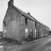
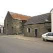
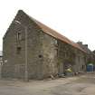
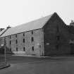
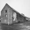
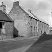
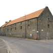
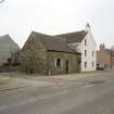
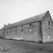
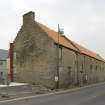
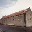
(Location cited as ND 118 683). Old Brewery, probably 18th century. A fine, 3-storey, 6-bay building with a 2-storey, 3-bay dwelling house (ND16NW 93) at the West end. Both have crow-stepped gables.
J R Hume 1977.
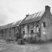
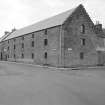
This three-storey, six-bay, rubble-built, harl-pinned brewery with crow-stepped gables and same height three-storey, three-bay brewer's house (ND16 NW 93) appear to date from the early nineteenth century and were located on Manson's Lane (formerly Manson's Street) and Riverside Place (formerly Cowgate), Thurso. These two con-joined buildings formed the S range of a brewery that formed a hollow square on the site, and is named as 'Brewery' and depicted as roofed on the Ordnance Survey, 1st Edition, 6-inch map (Caithness, 1877, sheet 5). Henderson (1812, 248) notes that a brewery was erected 'some years ago on a large scale in the town of Thurso. That business is still carried on, and Donnachie notes that the brewery is listed in Scottish Brewery Valuations for the period 1793-1815 (Donnachie, 274) as being owned by brewer Alex Manson and valued at £1000. The brewery is not listed in the 'List of Scottish Brewers' for 1825 (Donnachie, 263), because it was being used as a distillery (Moss and Hume, 272). The Original Name Book of the Ordnance Survey (ONB) of c.1877 notes that this brewery 'later became a distillery' but was no longer used as such (, Book 11, 128) and was in the ownership of a Miss Brodie. This building was demolished in the first week of April 2007.
The main brewery building comprised a three-storey, six-bay area measuring 25.0m in length by 7.5m in breadth overall. The second and third stories were unsafe and heavily contaminated with pigeon droppings and were not accessible on the date of visit. All flooring and posts were of timber.
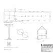
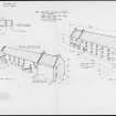
The ground floor interior consisted of a rectangular area with ingress through two doors. The door in the NE elevation, which measured 1.3m in width, would have opened out to what would have been the courtyard area and to the E of the forestair that allowed access to the upper floors. This forestair had been removed by the date of visit. The second door in the SW elevation door opened onto Manson's Lane. The wooden first storey floor was supported on a beam or girder that rested on seven wooden posts, which in turn rested on stone bases consisting of flat stones mortared together. Presumably these were to stop the base of the timbers rotting. These posts are approximately three imperial yards (c. 3.0m) apart and were roughly chamfered with a top tenon and a mortice into the main longitudinal beam or girder. A half lap joint with a tenon in the lower surface can be seen in the main beam or girder above the post at section B on RCAHMS drawing DC 51131). A wright's mark is visible above the post (see RCAHMS DC 51131). The posts were 5' 10" in length (1.8m), the overall height of the ground floor being 7' 6.5" (2.3m). The floor was of beaten earth and the walls and exposed timberwork appeared to have been painted white. The windows were splayed to maximise natural light and had sash windows and stone sills.
There was no evidence of any pre-1877 brewery activity on the ground floor, the building having been gutted many years ago. The number of windows suggests it was possibly not used for the storage valuable commodities (such as full beer kegs). There are no taking-in doors at first or second floor level suggesting that grain was not being loaded into the building from the street or the courtyard, although the presence of the forestair may have meant that grain was manually carried up into the upper floors. There was also an access from the street and the courtyard to a stairway that accessed the upper floors of the long range and the brewer's house. This first floor and second floor area could have been the Tun Room but since the building was in such a poor state of repair, and since the other ranges had been demolished, it is almost impossible to make any firmer comment of the use of this building range.
Visited by RCAHMS (MMD) April 2007.
Henderson (1812); ONB (1877); Donnachie (1979); Moss and Hume (1981)
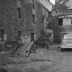
Photographic Record (October 1961)
Photographic survey of buildings in Thurso, Caithness by the Scottish National Buildings Record in October 1961.
Destruction (2008)
This former brewery building was demolished in c.2008. Housing now occupies the Manson Lane site.
Information from RCAHMS (MMD), 26 July 2013.
Field Visit (2008)
This three-storey, six-bay, rubble-built, harl-pinned brewery with crow-stepped gables and same height three-storey, three-bay brewer's house (ND16 NW 93) appear to date from the early nineteenth century and were located on Manson's Lane (formerly Manson's Street) and Riverside Place (formerly Cowgate), Thurso. These two con-joined buildings formed the S range of a brewery that formed a hollow square on the site, and is named as 'Brewery' and depicted as roofed on the Ordnance Survey, 1st Edition, 6-inch map (Caithness, 1877, sheet 5). Henderson (1812, 248) notes that a brewery was erected 'some years ago on a large scale in the town of Thurso. That business is still carried on, and Donnachie notes that the brewery is listed in Scottish Brewery Valuations for the period 1793-1815 (Donnachie, 274) as being owned by brewer Alex Manson and valued at £1000. The brewery is not listed in the 'List of Scottish Brewers' for 1825 (Donnachie, 263), because it was being used as a distillery (Moss and Hume, 272). The Original Name Book of the Ordnance Survey (ONB) of c.1877 notes that this brewery 'later became a distillery' but was no longer used as such (Caithness, Book 11, 128) and was in the ownership of a Miss Brodie. This building was demolished in the first week of April 2007.
The main brewery building comprised a three-storey, six-bay area measuring 25.0m in length by 7.5m in breadth overall. The second and third stories were unsafe and heavily contaminated with pigeon droppings and were not accessible on the date of visit. All flooring and posts were of timber.
The ground floor interior consisted of a rectangular area with ingress through two doors. The door in the NE elevation, which measured 1.3m in width, would have opened out to what would have been the courtyard area and to the E of the forestair that allowed access to the upper floors. This forestair had been removed by the date of visit.
The second door in the SW elevation door opened onto Manson's Lane. The wooden first storey floor was supported on a beam or girder that rested on seven wooden posts, which in turn rested on stone bases consisting of flat stones mortared together. Presumably these were to stop the base of the timbers rotting. These posts are approximately three imperial yards (c. 3.0m) apart and were roughly chamfered with a top tenon and a mortice into the main longitudinal beam or girder. A half lap joint with a tenon in the lower surface can be seen in the main beam or girder above the post at section B on RCAHMS drawing DC 51131). A wright's mark is visible above the post (see RCAHMS DC 51131). The posts were 5' 10" in length (1.8m), the overall height of the ground floor being 7' 6.5" (2.3m). The floor was of beaten earth and the walls and exposed timberwork appeared to have been painted white. The windows were splayed to maximise natural light and had sash windows and stone sills.
There was no evidence of any pre-1877 brewery activity on the ground floor, the building having been gutted many years ago. The number of windows suggests it was possibly not used for the storage valuable commodities (such as full beer kegs). There are no taking-in doors at first or second floor level suggesting that grain was not being loaded into the building from the street or the courtyard, although the presence of the forestair may have meant that grain was manually carried up into the upper floors. There was also an access from the street and the courtyard to a stairway that accessed the upper floors of the long range and the brewer's house. This first floor and second floor area could have been the Tun Room but since the building was in such a poor state of repair, and since the other ranges had been demolished, it is almost impossible to make any firmer comment on the use of this building range.
Visited by RCAHMS (MMD) April 2007.
Henderson (1812); ONB (1877); Donnachie (1979); Moss and Hume (1981)


