
Mid Bracco


Building (Medieval), Enclosure(S) (Post Medieval), Hut(S) (Post Medieval)
Site Name Mid Bracco
Classification Building (Medieval), Enclosure(S) (Post Medieval), Hut(S) (Post Medieval)
Canmore ID 83274
Site Number NS86NW 15.02
NGR NS 8344 6557
NGR Description Centred NS 834 655
Datum OSGB36 - NGR
Permalink http://canmore.org.uk/site/83274


- Council North Lanarkshire
- Parish Shotts (Monklands)
- Former Region Strathclyde
- Former District Monklands
- Former County Lanarkshire
Field Visit (31 May 1991)
NS86NW 15.02 centred 834 655
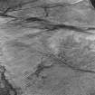
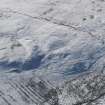
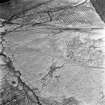
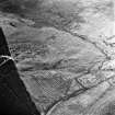
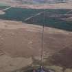
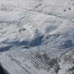
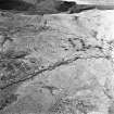
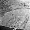
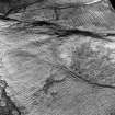
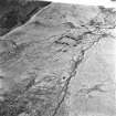
This turf-walled building (CSW 4623) is levelled in to the side of a shallow gully on the NNE side of a ridge to the SE of the stone-built farmstead (NS86NW 15.01). It comprises two compartments and measures 11m from ENE-WSW by 3.9m transversely within a grass-grown bank 1.2m in thickness and 0.4m in height. A bank runs off to the N, joining with the southernmost of three conjoined enclosures.
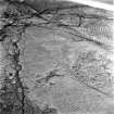
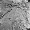
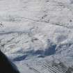
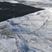
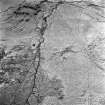
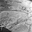
Around the building there are at least fourteen sub-rectangular turf-banked enclosures (some of which are conjoined), a turf-walled building and two huts. Four of the enclosures are cut by an L-shaped turf bank which encloses parts of the hill. A circular enclosure lies on the W edge of the group. Of the fourteen sub-rectangular enclosures there are two groups of three conjoined enclosures, in both cases with a sequence of construction. Entrances were not visible. Two huts are situated on small ledges along the leading edge of the terrace, the larger of which (CSW 4673) measures 5.8m by 3.2m within a turf bank 0.9m in thickness and 0.3m in height.
There are fragments of rig along the ridge to the SE of the turf-walled building, together with further fragmentary banks, running across the spine of the ridge. On the ridge to the SE, there are two circular turf-banked enclosures and a sub-rectangular enclosure which overlies rig. A small cairn (NS 8352 6541) measuring about 4m in diameter appears to pre-date the rig. A hut (CSW 4674), levelled into the N side of the ridge, measures 4.2m by 1.9m within a stony bank 0.9m in thickness and 0.2m in height.
Across the unnamed burn to the W of the group of enclosures, there are a further three small enclosures (NS 832 655), one of which may have a hut attached to its N side. A larger sub-rectangular enclosure, situated towards the southwestern extent of the cultivation remains, measures about 65m by 40m and overlies the rig.
(CSW 4623, 4673, 4674)
Visited by RCAHMS (DCC) 31 May 1991.
Note (20 August 2000)
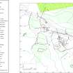
One enclosure is depicted at NS 8348 6571 on the 1st edition of the OS 6-inch map (Lanarkshire 1864, sheet ix). One small enclosure is shown on the current edition of the OS 1:10000 map (1986).
Information from RCAHMS (AKK) 20 August 2000.
Field Visit (9 November 2004 - 21 February 2008)
Headland Archaeology Ltd undertook a Cultural Heritage Assessment of the predicted impacts of the proposed windfarm on cultural heritage features.
A targeted walk-over survey was undertaken (9 November 2004 and 21 February 2008) in order to verify the findings of the desk-based assessment and to identify any previously unrecorded sites within the construction footprint of the scheme. Sites were visted as necessary in order to gather data regarding their setting.
There are two designated cultural heritage features within the inner study area. These comprise Mid Bracco deserted farmstead and Mid Bracco hut circles. The latter lies entirely within the inner study area, whilst the greater part of Mid Bracco deserted farmstead lies outside to the south-east.
Potential construction and operational impacts upon cultural heritage features have been considered and assessed. It has been concluded that, following the implementation of a programme of archaeological works, there will be no significant effects in terms of the EIA (Scotland) regulations 1999. Residual effects will be of minor or lesser significance.
Information from Headland Archaeology Ltd

