 |
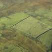
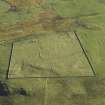
On-line Digital Images |
DP 021198 |
RCAHMS Aerial Photography Digital |
Oblique aerial view centred on the remains of the township, taken from the NE. |
2/11/2006 |
Item Level |
|
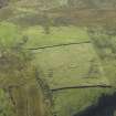 |
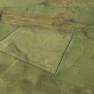
On-line Digital Images |
DP 021199 |
RCAHMS Aerial Photography Digital |
Oblique aerial view centred on the remains of the township, taken from the N. |
2/11/2006 |
Item Level |
|
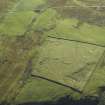 |
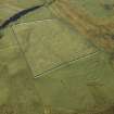
On-line Digital Images |
DP 021200 |
RCAHMS Aerial Photography Digital |
Oblique aerial view centred on the remains of the township, taken from the NNW. |
2/11/2006 |
Item Level |
|
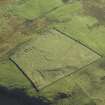 |
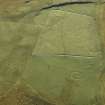
On-line Digital Images |
DP 021201 |
RCAHMS Aerial Photography Digital |
Oblique aerial view centred on the remains of the township, taken from the NW. |
2/11/2006 |
Item Level |
|
 |
On-line Digital Images |
DP 021202 |
RCAHMS Aerial Photography Digital |
Oblique aerial view centred on the remains of the township, taken from the W. |
2/11/2006 |
Item Level |
|
 |
On-line Digital Images |
DP 021203 |
RCAHMS Aerial Photography Digital |
Oblique aerial view centred on the remains of the township, taken from the WSW. |
2/11/2006 |
Item Level |
|
 |
On-line Digital Images |
DP 021204 |
RCAHMS Aerial Photography Digital |
Oblique aerial view centred on the remains of the township, taken from the SSW. |
2/11/2006 |
Item Level |
|
 |
On-line Digital Images |
DP 021205 |
RCAHMS Aerial Photography Digital |
Oblique aerial view centred on the remains of the township, taken from the SSE. |
2/11/2006 |
Item Level |
|
|
All Other |
551 166/1/1 |
Records of the Ordnance Survey, Southampton, Hampshire, England |
Archaeological site card index ('495' cards) |
1947 |
Sub-Group Level |
|


