
Pricing Change
New pricing for orders of material from this site will come into place shortly. Charges for supply of digital images, digitisation on demand, prints and licensing will be altered.
Hillhead


Colliery (19th Century) - (20th Century)
Site Name Hillhead
Classification Colliery (19th Century) - (20th Century)
Canmore ID 82680
Site Number NS86NE 34
NGR NS 8607 6960
Datum OSGB36 - NGR
Permalink http://canmore.org.uk/site/82680


- Council Falkirk
- Parish New Monkland (Falkirk)
- Former Region Central
- Former District Falkirk
- Former County Lanarkshire
Field Visit (10 August 1992)
NS86NE 34 8607 6960
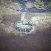
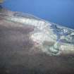
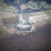
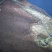
The remains of three bings and a plinth for winding-gear are situated on the S of Black Loch. Two of the bings lie beside the loch; the E bing is conical with a ridge for conveyor running up its N side, and the W bing has brick building foundations on the W. The third bing, which lies 200m to the S, is crow's foot-shaped on plan and flat-topped with a tramway leading to it. The 2nd edition of the OS 6-inch map depicts the mine, called 'Hillhead Pit No.1', as three buildings and shows a railway siding leading W from the mine (Lanarkshire 1899, sheet iv). By the revised edition of the OS 6-inch map there were two bings on either side of the pit-head buildings (Lanarkshire 1921, sheet iv, resurveyed 1910). All levels had been abandoned by June 1930 (Mines Department 1931).
(CSW 4356)
Visited by RCAHMS (PJD) 10 August 1992

