
Mountcow


Mine (Period Unassigned)
Site Name Mountcow
Classification Mine (Period Unassigned)
Canmore ID 82182
Site Number NS86SW 25
NGR NS 8203 6436
Datum OSGB36 - NGR
Permalink http://canmore.org.uk/site/82182


- Council North Lanarkshire
- Parish Shotts (Monklands)
- Former Region Strathclyde
- Former District Monklands
- Former County Lanarkshire
Field Visit (30 June 1992)
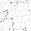
NS86SW 25 8203 6436.
This mine is situated in low-lying ground about 400m E of the NE end of Roughrigg Reservoir, on the N side of a track which runs WSW from Mountcow farm. A depression beside the track at NS 8203 6436 may mark the position of the shaft; there are spoil tips to either side of this, and about 100m to the NNW there is another bing overlying a stretch of tramway. The former Dunsiston Branch Line passes immediately to the SW of the site, and there is a short siding adjacent to the mine. The bing on the ENE side of the shaft and the one to the NNW are depicted on the 2nd edition of the OS 6-inch map (Lanarkshire 1899, sheet viii.SE), by which time the site appears to have been abandoned. The revised edition of the OS 6-inch map (Lanarkshire 1913, sheet viii, resurveyed in 1910) also depicts spoil tips to the W of the shaft, suggesting that the site had been reused in the intervening years.
This site may have been associated with a group of remains 400m to the E (NS86SW 6).
(CSW 4204)
Visited by RCAHMS (SDB) 30 June 1992

