
Pricing Change
New pricing for orders of material from this site will come into place shortly. Charges for supply of digital images, digitisation on demand, prints and licensing will be altered.
Castlesteads


Pit (Period Unassigned)
Site Name Castlesteads
Classification Pit (Period Unassigned)
Canmore ID 82090
Site Number NT36NW 150
NGR NT 3391 6945
Datum OSGB36 - NGR
Permalink http://canmore.org.uk/site/82090


- Council Midlothian
- Parish Inveresk (Midlothian)
- Former Region Lothian
- Former District Midlothian
- Former County Midlothian
NT36NW 150 3391 6945
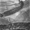
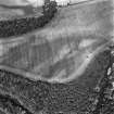
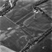
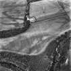
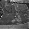
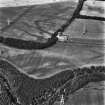
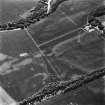
A pit, which appears to be square on plan, has been recorded as a cropmark on oblique aerial photographs (RCAHMSAP).
Information from RCAHMS (MMB) 3 February 2005
Site identified during an archaeological assessement carried out by CFA Archaeology Ltd.
Mhairi Hastie, 2006.

