Dorus Ailein
Clearance Cairn(S) (Period Unassigned)
Site Name Dorus Ailein
Classification Clearance Cairn(S) (Period Unassigned)
Alternative Name(s) Lat 277
Canmore ID 8155
Site Number ND13SE 37
NGR ND 1835 3143
NGR Description Centred ND 1835 3143
Datum OSGB36 - NGR
Permalink http://canmore.org.uk/site/8155
- Council Highland
- Parish Latheron
- Former Region Highland
- Former District Caithness
- Former County Caithness
ND13SE 37 centred 1835 3143.
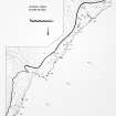
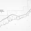
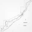
ND 1835 3143. A cairnfield of unknown period, covering an area about 500 by 200m on a slope above the cliff edge at Dorus Ailein, and consisting of about fifteen roughly circular, grass-grown, small stone mounds, the largest 10 by 8m and the greatest height 1.5m, the average being 0.5m.
C Batey 1982.
A number of stony mounds on a steep, grassy and bracken-overgrown slope. Some may be natural, but others are undoubtedly stone clearance heaps, probably from early-modern land-use.
Visited by OS (J M) 13 October 1982.
Project (1980 - 1982)
Field Visit (13 October 1982)
A number of stony mounds on a steep, grassy and bracken-overgrown slope. Some may be natural, but others are undoubtedly stone clearance heaps, probably from early-modern land-use.
Visited by OS (J M) 13 October 1982.
Field Visit (1982)
ND 1835 3143. A cairnfield of unknown period, covering an area about 500 by 200m on a slope above the cliff edge at Dorus Ailein, and consisting of about fifteen roughly circular, grass-grown, small stone mounds, the largest 10 by 8m and the greatest height 1.5m, the average being 0.5m.
C Batey 1982.


