
Geldie Lodge


Building Platform (Post Medieval), Pen(S) (Post Medieval), Shieling Hut(S) (Post Medieval)
Site Name Geldie Lodge
Classification Building Platform (Post Medieval), Pen(S) (Post Medieval), Shieling Hut(S) (Post Medieval)
Alternative Name(s) Mar Lodge Estate
Canmore ID 81428
Site Number NN98NE 1.03
NGR NN 9555 8668
Datum OSGB36 - NGR
Permalink http://canmore.org.uk/site/81428


- Council Aberdeenshire
- Parish Crathie And Braemar
- Former Region Grampian
- Former District Kincardine And Deeside
- Former County Aberdeenshire
Field Visit (4 May 1993)
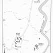
NN98NE 1.03 9556 8669
There are three huts, a building-stance and two pens on the banks of the Allt Coire an t-Seilich to the E of Geldie Lodge (NN98NE 1.01). The building stance, which is a level platform edged by stones, measures 4.7m from N to S by 2.6m transversely (MAR93 157). It is possible that this is the structure depicted as roofed on the 1st and 2nd editions of the OS 6-inch map (Aberdeenshire 1869 and 1903, Sheet xcvi). The three huts are constructed of turf and stone, and range in length from 7.6m to 10.9m by between 3.5m and 5.5m in breadth overall. The two huts on the W of the burn (MAR93 155-6) are subdivided into two compartments and that to the S, which has an outshot on its N end, is built of faced-rubble, largely revealed as robber trenches, with an external turf embankment (MAR93 155). The hut to the E of the burn (MAR93 160) is situated on a bend in the burn about 70m to the NNE. The pens (MAR93 158-9) are both subrectangular in shape, that to the N has been cut into the slope of the ground near the edge of the burn and measures 4.7m from N to S by 4m transversely with an upcast bank on the E side 2m thick and 0.55m in height, the S pen measures 8.2m from N to S by 5.2m over stony banks spread to 0.9m in thickness and 0.3m in height with an entrance in the NW corner.
(MAR93 155-160)
Visited by RCAHMS (PJD) 4 May 1993

